Scientific mining could have mitigated flood damage in Punjab: IIT Ropar faculty
In its proposal, IIT Ropar has suggested bathymetry for the analysis of underwater sand mining.
 IIT Ropar civil engineering department assistant professor Reet Kamal Tiwari who has anchored the draft report on river sand mining in Punjab told The Indian Express, “I am not against the mining but against unplanned and unscientific mining. Punjab is known as a land of rivers. (Express Photo by Gurmeet Singh)
 Punjab needs to rein in ‘mafia’ and has much more potential for mining the quantity of sand and minerals from its rivers than which is actually being mined, as per experts of the Indian Institute of Technology Ropar.
Punjab government is mulling a collaboration with premiere research institute on river sand mining and its socio-environmental sustainability for which IIT Ropar has prepared a draft report.
In the current fiscal, 518 mining sites in 14 districts of Punjab have been notified to extract nearly 1300 lakh metric tonnes of sand. Ropar leads with an extraction ceiling of 174 lakh metric tonnes, followed by 162.7 lakh metric tonnes in Nawanshahr and 136 lakh metric tonnes, 129 lakh metric tonnes and 114 lakh metric tonnes, in the respective districts of Pathankot, Amritsar and Ludhiana.
IIT Ropar civil engineering department assistant professor Reet Kamal Tiwari who has anchored the draft report on river sand mining in Punjab told The Indian Express, “I am not against the mining but against unplanned and unscientific mining. Punjab is known as a land of rivers. There are massive resources and scientific mining is what is needed. What Punjab government is mining is very less than the potential which is there.”
Tiwari said there are several factors which needed to be taken into account to improve sand mining in the state. “As an academician, I can pinpoint these factors. For instance, we need to have a regulatory mechanism to check mining from inside the water. I understand that it is no fault of Punjab government which cannot depute officials to check where all mining inside the water channels or rivers is taking place. It is a difficult task. Apart from the visible area, we have proposed to survey the area under the water. The idea is to maintain eco-flow of the river. The illegal mining in the river water results in formations of ditches, sort of artificial lakes which hamper the eco-flow.”
In its proposal, IIT Ropar has suggested bathymetry for the analysis of underwater sand mining. The technique involves mapping of riverbed by using a drone which would point out any unexpected depression on the surface of river.
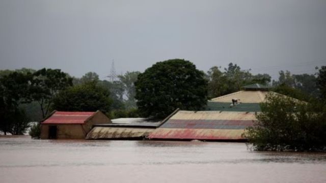
Dr Tiwari said that scientific mining along Beas river could have mitigated the damage caused by the floods in the monsoon. “As per my understanding of geomorphology, the storage capacity of the Beas river would have been much better and magnitude of damage caused by floods much less had there was proper and scientific mining,” Dr Tiwari told The Indian Express.’
“Second thing. What is happening that government is approving fixed quantity from a particular site that creates a ditch in a particular area and that increases the vulnerability of that area. Our say is that we can mine some sand from an area and after that move to the lower region downstream. By doing so we will maintain the slope of the river and the eco-flow.” Dr Tiwari also told that during meetings with Punjab government officials, it also came to light that ‘mafias’ were purchasing land surrounding the river banks and subsequently “blackmailing” the government.
“In this scenario, scientific and digital data is very crucial. This is part of our proposal. Digitisation of the land transaction surrounding the river banks is part of the proposal which would help us ascertain if any mafia has purchased land chunks around the river banks,” said Dr Tiwari, pointing out that the owners of the land surrounding river banks get allured to sell land by the ‘mafia’ due to vulnerability in times of floods.
“Our motive is that the money (earned from mining) should go directly to the land owners. And if contractor is involved, the land owners should get their fair due.”
In its proposal, IIT Ropar has proposed quantification of sand mined and monitoring of riverbeds using satellite data by preparing a base layer of complete river.
For volumetric analysis, it has suggested methods such as UAV (Unmanned Aerial Vehicle) survey to conduct drone mapping with photographic evidence; LiDAR (3-D modelling by using laser technique); DGPS (Differential Global Positioning System); and bathymetry (for underwater areas).
You May Like