


© The Indian Express Pvt Ltd
Tags:
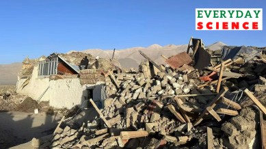
Tibet Earthquake News: An earthquake measuring around 7 on the Richter scale hit Tibet on Tuesday (January 7), killing around 100 people and damaging about 1,000 houses. Its epicentre was about 75 kilometres northeast of Mount Everest and close to Nepal, but no major damage was reported there.
According to the United States Geological Survey, 10 earthquakes of at least magnitude 6 have occurred in the area impacted on Tuesday over the past century. This frequency results from the unique movements of tectonic plates that make up the Earth’s crust. But what makes this region among the most earthquake-prone zones in the world? We explain.
The entirety of Earth’s outermost surface (the crust and the upper mantle) is composed of 15 major and minor plates. Earthquakes are a result of movement along faults, which are breaks in the tectonic plates.
The USGS website notes, “The tectonic plates are always slowly moving, but they get stuck at their edges due to friction. When the stress on the edge overcomes the friction, there is an earthquake that releases energy in waves that travel through the earth’s crust and cause the shaking that we feel.”
In 2023, for instance, a major earthquake in Turkey happened due to interactions between the African, Eurasian, and Arabian plates. The Arabian plate is known to be pushing northward, leading to a slight westward movement for the Anatolian plate, where Turkey is located.
Plates move because of the processes happening deep underneath the Earth’s surface. For one, temperature and pressure rise as one goes deeper, resulting in convection currents of varying intensity circulating throughout the mantle.

What about the Himalayan region?
The Himalayan mountain range began forming around 40 to 50 million years ago when the Eurasian and Indian plates first began pushing into each other. As both plates were of a similar density, their point of collision resulted in the uplifting of land.
Over time, the continued stretching of the Eurasian plate led to its subsidence, that is, it slipped underneath the Indian plate. This process continues today. According to the USGS, “Seismicity in the Himalaya dominantly results from the continental collision of the India and Eurasia plates, which are converging at a relative rate of 40-50 mm/yr.”
At least five earthquakes of magnitude greater than 7 have struck the Hindu Kush region since 1950. Seismologist Sankar Kumar Nath earlier told The Indian Express, “This region has a peculiar tectonic formation. While the Indian plate is getting under the Himalayas, a phenomenon that is occurring all along the Himalayan range, the Eurasian plate is getting subducted under the Pamir mountains. In addition, there are several other faultlines. This is the convergence point for several seismic forces.”
Threat of future earthquake
The western Himalayas are one of the most dangerous seismic zones in the world. Scientists have long said that the larger region spanning 2,500 km from the Hindu Kush to Arunachal Pradesh is due for a big quake, of magnitude over 8. A huge amount of energy is stored along the faultlines due to the continuous interaction of tectonic plates — which can be released only in the form of a massive quake.
A 2017 study (‘Implications for elastic energy storage in the Himalaya from the Gorkha 2015 earthquake and other incomplete ruptures of the Main Himalayan Thrust’) published in Quaternary International found that only two Himalayan earthquakes in the past 500 years have ruptured to the surface.
Its lead author Roger Bilham told National Geographic, “What that means is, there’s a whole bunch of regions that I call ‘reservoirs of elastic energy’ that are sitting there waiting to go”. Given the unpredictability of earthquakes, the potential damage from such an event could be significant.

