


Stay updated with the latest - Click here to follow us on Instagram
© The Indian Express Pvt Ltd
Tags:
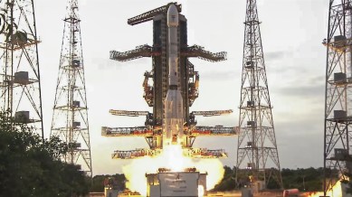
In its most significant launch since the Moon-landing Chandrayaan-3 in 2023, the Indian Space Research Organisation (ISRO) on Wednesday placed NISAR satellite, a first-of-its-kind collaborative project between India and the US, into its intended orbit.
NISAR, which stands for NASA-ISRO Synthetic Aperture Radar, is the most powerful Earth observation satellite to be put in space, the result of over one decade of research and development by the space agencies of India and the US.
The uniqueness of the satellite lies in the fact that it carries two Synthetic Aperture Radars (SARs) of different frequencies that are designed to work together to produce some of the most detailed images of the Earth ever captured from space. SARs are imaging equipment that use the non-visible microwave radiation to create pictures of the Earth from space. Never before have two SARs been mounted on a single satellite.
The NISAR satellite flew on a GSLV rocket launched from Sriharikota Wednesday evening. The satellite was deposited in the Sun Synchronous Polar Orbit (SSPO), about 747 km from the Earth, within 19 minutes of the launch. This was the first time that ISRO used its powerful GSLV rocket to drop a satellite in the SSPO. Usually, the PSLV rocket is used to access these orbits, but NISAR satellite was too heavy to be handled by PSLV. In fact, at 2,392 kgs, NISAR is the heaviest Earth observation satellite ever.
“This is the first mission to SSPO using the GSLV. Therefore, several analysis and studies were carried out to make it a grand success, including cryogenic upper stage corrections and a host of mission simulations. The vehicle performance today was as expected and predicted,” ISRO Chairman V Narayanan said after the launch.
This was ISRO’s first successful launch since Narayanan took over as chairman in January. Two earlier launches this year were unsuccessful.
NISAR is meant to take high-resolution pictures of the Earth, which will be useful for a wide range of research activities, including in climate change, disaster management, agriculture, forestry and urban planning. The two SARs, working in tandem, can map the terrain in minute detail, and, by repeating their observations in a cyclic fashion, can capture the changes happening at as small a scale as one centimetre.
Narayanan said the satellite was injected just 2 km off the planned orbit. This was a very small difference and much less than the margin of error with which this satellite can perform, he said.
After the injection into orbit, a key event would be the unfurling of a 12-metre foldable antennae. The unfurling will be a slow process to ensure that the delicate system is not damaged during the process. It will start 10 days later and will happen over the next eight days.
To further prepare for the scientific observations, the satellites will complete deployment and testing of all parts over the next 90 days and then carry out calibration and validation over the next five months.
Science Minister Jitendra Singh, who witnessed the launch over video in Delhi because of the ongoing Parliament session, said this was another major achievement of the Indian space establishment, after the spaceflight by Shubhanshu Shukla on the Axiom-4 mission last month.
“This is another collaborative mission with NASA that comes quick on the heels of the ISS mission with astronaut Shubhanshu Shukla. It is one of the biggest collaborations between leading space agencies. Today, we are in a position to be equal partners with NASA, which started much before our space programme,” he said.
NISAR satellite would map the entire globe every 12 days, providing a series of detailed images that can have various applications ranging from predicting disasters, helping in rescue efforts afterwards, developing new models for earthquakes and volcanic eruptions, and most importantly studying the impacts of climate change. The mission life of the satellite is five years.
Stay updated with the latest - Click here to follow us on Instagram

