Why do landslides occur, and what triggered the tragedy in Wayanad?
2024 has been marked by landslides around the world. Their frequency is increasing as the impacts of climate change intensify. Plantation farming and extremely heavy rain in Kerala contributed to the Wayanad tragedy. Here’s how.
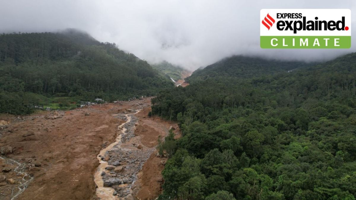
Helicam picture of Chooralmala, Wayanad
(Photo - PRD, Kerala)
This year has seen a series of landslides around the world — from Yunnan in China in January to Papua New Guinea in May that killed more than 2,000 to Sulawesi island in Indonesia and Wayanad in Kerala in July.
The death toll from the series of landslides in Meppadi in Wayanad district had reached 276 on Thursday (August 1) morning, with at least 240 people still missing. Some 200 people are injured.
Landslides are not considered to be as devastating as droughts, storms, or floods. They are also less studied because they are localised events. But their frequency is increasing as the effects of climate change intensify, and they are causing significant losses of lives and livelihoods.
You’ve Read Your Free Stories For Now
Sign up and keep reading more stories that matter to you.
India accounts for about 8% of global fatalities due to landslides, and during the period 2001-21, landslides caused 847 deaths and displaced thousands, according to a team from IIT-Madras that has worked on the phenomenon.
Despite the significant number of fatalities however, landslides were not given enough importance in India until the 2013 Kedarnath landslide and floods, the team has noted.
The IIT-M team has developed a high-resolution India Landslide Susceptibility Map (ILSM) using machine learning models.
According to a paper published in IIT-M’s Shaastra magazine, the ILSM shows that 13.17% of the country is susceptible to landslides, which is more than what was believed previously. And 4.75% area is considered “very highly susceptible”.
Story continues below this ad
“Sikkim has the largest land area (57.6%) that is landslide-prone, while outside of the Himalayas, Kerala is the most vulnerable state with over 14% of its land mass in the “very high susceptibility” category.
“Some areas in the Eastern Ghats, around Odisha, too, are susceptible – which previous studies had missed. Arunachal Pradesh has the largest susceptible area (31,845 sq km), which other models had missed because of paucity of data on landslides,” the paper says.
In 2023, the Indian Space Research Organisation (ISRO) released a “Landslide Atlas of India”, identifying the landslide hotspots around the country. Among the highly vulnerable areas in the atlas were the Himalayas and the Western Ghats.
What factors cause landslides?
Landslides are natural phenomena that usually occur in mountainous regions with steep slopes. During a landslide, large amounts of rock, boulders, loose mud, soil, and debris roll down slopes and hillsides, gathering great momentum and often taking vegetation or buildings along.
Story continues below this ad
Landslides are seen as being caused by (i) conditioning factors and (ii) triggering factors.
CONDITIONING FACTORS are related to the soil topography, rocks, geomorphology, and slope angles, among other factors. These factors make some parts of the country more vulnerable to landslides than other parts.
TRIGGERING FACTORS are intense rainfall, and anthropological activities such as thoughtless changes of land use, road and bridge building, haphazard and unscientific construction, and large-scale destruction of forests.
How did these broad factors apply in the case of Kerala?
S Abhilash, director of the Advanced Centre for Atmospheric Radar Research (ACARR) at Cochin University of Science and Technology, Kochi, told The Indian Express that the cutting of trees to create plantations is contributing to landslides in Kerala.
“Most of the landslides that are taking place in Kerala are around plantation areas, indicating another major triggering factor — agricultural activities such as monocropping, in which large, native trees, which hold the top soil to the bedrock, are cut down. These trees are being replaced by big plantation crops, such as tea and coffee, which have shallow roots,” he said.
Research carried out by Dr Abhilash and his team in 2019 in Puthumala, which is close to the place where the landslides of this week took place, found that certain atmospheric conditions made the area vulnerable to very heavy rainfall in a small window, which increased the likelihood of landslides.
“What we observed in 2019 was that it was due to a kind of mesoscale organization of big convective cloud clusters, which produced more than 5-10 centimetres of rain over two to three hours… So, that type of rainfall is becoming more common along Kerala,” Dr Abhilash said.
Indeed, two weeks of continuous rainfall, 50-70% above normal for this time, set the conditions for the disaster in Wayanad. This rain saturated the topsoil, and when a day of extremely heavy rain akin to a mini cloudburst followed, the landslide event was triggered.
Dipanita Nath is a Senior Assistant Editor at The Indian Express, based in Pune. She is a versatile journalist with a deep interest in the intersection of culture, sustainability, and urban life.
Professional Background
Experience: Before joining The Indian Express, she worked with other major news organizations including Hindustan Times, The Times of India, and Mint.
Core Specializations: She is widely recognized for her coverage of the climate crisis, theatre and performing arts, heritage conservation, and the startup ecosystem (often through her "Pune Inc" series).
Storytelling Focus: Her work often unearths "hidden stories" of Pune—focusing on historical institutes, local traditions, and the personal journeys of social innovators.
Recent Notable Articles (December 2025)
Her recent reporting highlights Pune’s cultural pulse and the environmental challenges facing the city during the winter season:
1. Climate & Environment
"Pune shivers on coldest morning of the season; minimum temperature plunges to 6.9°C" (Dec 20, 2025): Reporting on the record-breaking cold wave in Pune and the IMD's forecast for the week.
"How a heritage tree-mapping event at Ganeshkhind Garden highlights rising interest in Pune’s green legacy" (Dec 20, 2025): Covering a citizen-led initiative where Gen Z and millennials gathered to document and protect ancient trees at a Biodiversity Heritage Site.
"Right to breathe: Landmark NGT order directs PMC to frame norms for pollution from construction sites" (Dec 8, 2025): Reporting on a significant legal victory for residents fighting dust and air pollution in urban neighborhoods like Baner.
2. "Hidden Stories" & Heritage
"Inside Pune library that’s nourished minds of entrepreneurs for 17 years" (Dec 21, 2025): A feature on the Venture Center Library, detailing how a collection of 3,500 specialized books helps tech startups navigate the product life cycle.
"Before he died, Ram Sutar gave Pune a lasting gift" (Dec 18, 2025): A tribute to the legendary sculptor Ram Sutar (creator of the Statue of Unity), focusing on his local works like the Chhatrapati Shivaji statue at Pune airport.
"The Pune institute where MA Jinnah was once chief guest" (Dec 6, 2025): An archival exploration of the College of Agriculture, established in 1907, and its historical role in India's freedom struggle.
3. Arts, Theatre & "Pune Inc"
"Satyajit Ray, Ritwik Ghatak were not rivals but close friends, says veteran filmmaker" (Dec 17, 2025): A deep-dive interview ahead of the Pune International Film Festival (PIFF) exploring the camaraderie between legends of Indian cinema.
"Meet the Pune entrepreneur helping women build and scale businesses" (Dec 16, 2025): Part of her "Pune Inc" series, profiling Nikita Vora’s efforts to empower female-led startups.
"How women drone pilots in rural Maharashtra are cultivating a green habit" (Dec 12, 2025): Exploring how technology is being used by women in agriculture to reduce chemical use and labor.
Signature Style
Dipanita Nath is known for intellectual curiosity and a narrative-driven approach. Whether she is writing about a 110-year-old eatery or the intricacies of the climate crisis, she focuses on the human element and the historical context. Her columns are often a blend of reportage and cultural commentary, making them a staple for readers interested in the "soul" of Pune.
X (Twitter): @dipanitanath ... Read More