


© IE Online Media Services Pvt Ltd
Tags:
— Abhinav Rai
The Ganga River is among several prominent rivers where stretches were identified to have deteriorated in water quality, according to a Central Pollution Control Board (CPCB) assessment report released last week.

On World Rivers Day, held on the fourth Sunday of September annually to celebrate rivers and raise awareness about the importance of protecting them, let’s understand the vital need for maintaining the Ganga basin’s ecological balance and conserving its soil and water resources.
The Ganga river basin spans approximately 10,86,000 sq km across India, Nepal, Tibet (China), and Bangladesh. About 80 per cent of this basin area (8,61,452 sq km) lies in India, covering more than one-fourth (approximately 27 per cent) of the country’s total geographical area. The basin extends across 11 Indian states: Uttarakhand, Uttar Pradesh, Delhi, Haryana, Rajasthan, Madhya Pradesh, Bihar, Jharkhand, Chhattisgarh and West Bengal.
The Ganga forms when the Bhagirathi – originating from Gangotri glacier near Gaumukh – and Alaknanda streams merge at Devprayag. The river enters the plains near Haridwar and travels about 2,525 km before falling into the Bay of Bengal. Its major tributaries include the Yamuna and Son on the right bank, and the Ramganga, Kali, Gomti, Ghaghra, Gandak, and Kosi on the left bank. After crossing the Farakka Barrage, the river bifurcates into the Hooghly, which flows into the Bay of Bengal, and the Padma, which flows into Bangladesh.
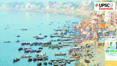
The Ganga Basin’s flat plain, with its fertile soil, suitable climate and the availability of water for drinking and irrigation, makes it one of the most densely populated regions in the world. According to the 2011 Census, India’s average population density was 382 persons per sq km, whereas some basin states recorded significantly higher densities – like Delhi (11,297), Bihar (1,102), West Bengal (1,029), Uttar Pradesh (828), Jharkhand (414), and Uttarakhand (189).
The basin can be divided into three stretches:
— Upper Ganga Basin: From the origin to Narora Barrage.
— Middle Ganga Basin: From the Narora Barrage to Ballia District, Uttar Pradesh.
— Lower Ganga Plain: From Ballia to the Bay of Bengal.
The middle and lower Ganga basins have the highest population densities with major urban centers like Lucknow, Kanpur, Allahabad, Varanasi and Patna.
Over 65 per cent of the Ganga basin is used for agriculture, and 3.47 per cent is covered by water bodies. Despite receiving 35.5 per cent of its water from precipitation, it ranks as India’s second most water-stressed basin after Sabarmati. The extensive fertile plains with irrigation facilities are suitable for double and triple cropping systems, attracting population concentration.
More than 52 per cent of the basin contains alluvial soil, particularly concentrated in upper and middle Ganga plains. This soil is rich in potash and plant nutrients but deficient in phosphorus, and supports intensive cultivation. Alluvial soil is of two types: Khadar (new alluvium from recent flooding) and Bhangar (old alluvium found away from flood plains). The lower Ganga plain has diverse soil varieties, including lateritic, red, alluvial, and coastal soils. The river also forms one of the largest deltas in the world, the Sundarbans, which is predominantly covered by Sundari trees.
The basin is rich in surface and sub-surface water resources with an estimated potential of 525.02 billion cubic meters (BCM). The primary sources include rainfall, seasonal snow and glacier melt, and subsurface flows. While the catchment area of the peninsular tributaries is large, they contribute only 40 per cent of the basin’s water and the remaining 60 per cent comes from Himalayan streams.
There are 784 dams across the basin, with the highest number being in Madhya Pradesh (364), followed by Rajasthan (145) and Uttar Pradesh (98). The Tehri dam is the highest at 260.5 meters, and the Nanak Sagar Dam is the longest at 19.2 km. According to the India-WRIS report, the Ganga basin has 478 major and medium irrigation projects and 39 hydro-electric projects. In addition, the basin’s easily accessible groundwater resources account for nearly 50 per cent of India’s total groundwater-irrigated area.
But the Ganga basin is facing severe pollution and growing threats to its biodiversity and environmental sustainability. Around 47 per cent of India’s population depends on the Ganga basin for drinking water, irrigational needs, and other ecosystem services. The basin’s average population density here is about 520 persons per sq km. However, this density varies geographically, generally decreasing from east to west. In the Lower Gangetic Plains, population pressure has exceeded the carrying capacity of available land and water resources.
This dependency causes resource over-exploitation. According to the World Bank’s estimates, about 2,700 million liters of wastewater are discharged daily into the basin. The Middle Ganga Basin is the most polluted stretch among all, with 500 million liters of industrial waste drained daily into the basin. It has resulted in widespread environmental degradation and public health crises, including infant deaths from waterborne diseases, land degradation, and biodiversity loss.
The Ganga basin faces severe challenges, including river pollution, annual flooding, groundwater depletion, and contamination. Several states report ground water contamination from arsenic, fluoride, iron, nitrate, chloride, etc. Rainfall mostly occurs during monsoon (June to September), which causes acute fluctuations in river flow and leads to annual flood hazards, particularly in parts of Uttar Pradesh, Bihar and West Bengal. The Kosi River, often called the ‘Sorrow of Bihar’, is known for frequently changing courses and causing disastrous floods.
To reduce pollution levels, the Ganga Action Plan-I (GAP-I) was initiated in 1985, which targeted 25 towns in Uttar Pradesh, Bihar, and West Bengal. It was followed by GAP-II in 1993. In 2009, the National Ganga River Basin Authority (NGRBA) was established to coordinate planning, financing and monitoring of conservation programmes.
The flagship ‘Namami Gange’ programme was launched in June 2014 and aims to achieve effective pollution abatement, conservation, and rejuvenation. The programme aims to ensure ‘Aviral Dhara’ (continuous flow), and ‘Nirmal Dhara’ (unpolluted flow) by conserving its geological and ecological integrity.
However, despite four decades of policy interventions and financial investments, the outcome has been limited. There is a need for incentive-based policies with clear socio-economic gains, supported by regular evaluation and course correction mechanisms.
The Ganga basin is often described as the lifeline of India, sustaining one of the most densely populated regions in the world. However, this huge population concentration has also created imbalances between human demands and the capacity of land, soil and water resources in the basin. The unchecked exploitation of the basin’s resources has led to river pollution, ground water depletion, contamination, flooding, biodiversity loss, etc.
The future sustainability of the basin demands balancing developmental needs with conservation measures. The path forward needs to shift from reactive pollution control to proactive ecosystem management by utilising cutting-edge technology and encouraging community participation across the entire Ganga basin.
Why is groundwater depletion and contamination a critical issue in the Ganga basin?
How do industrial and domestic wastewater contribute to the degradation of the Ganga ecosystem?
What are the consequences of unchecked resource exploitation in the Ganga Basin in terms of widespread environmental degradation and public health crises?
Despite several government programs like GAP-I (the Ganga Action Plan-I), GAP-II, the National Ganga River Basin Authority, and Namami Gange, why have results in cleaning the Ganga remained limited?
Suggest strategies to balance developmental needs with ecological conservation in the basin.
(Abhinav Rai is a Doctoral candidate at the Department of Geography, Delhi School of Economics, University of Delhi.)
Share your thoughts and ideas on UPSC Special articles with ashiya.parveen@indianexpress.com.
Subscribe to our UPSC newsletter and stay updated with the news cues from the past week.
Stay updated with the latest UPSC articles by joining our Telegram channel – IndianExpress UPSC Hub, and follow us on Instagram and X.


