


© IE Online Media Services Pvt Ltd
Tags:

NASA is monitoring Hurricane Dorian as it continues to advance through the Atlantic Ocean. Several satellites have captured multiple images and taken out different types of data from the gigantic storm. The US space agency also released a video taken from the International Space Station (ISS).
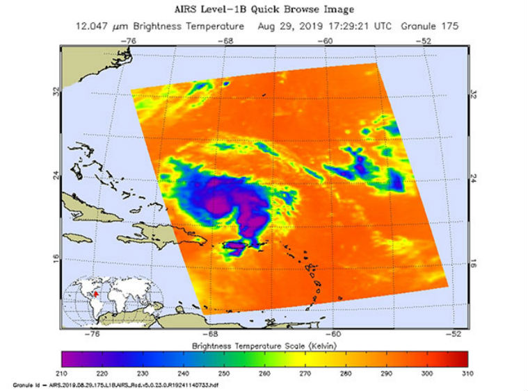
With the help of the Atmospheric Infrared Sounder (AIRS) which is equipped in NASA’s Aqua satellite, the space agency could able to gather the information of the temperature, humidity, cloud volume and height of Hurricane Dorian.

In the AIRS image released by NASA, the large purple area indicates very cold clouds that are carried high into the atmosphere by deep thunderstorms. These clouds are also associated with heavy rainfall. The blue and green indicate warmer areas with shallower rain clouds, while the orange and red areas represent mostly cloud-free air.
In the next image, weather-observing satellite TEMPEST-D took the imagery of Dorian off the coast of Puerto Rico. At a height of 250 miles (400 kilometres) above the weather system, the cubesat used its miniaturized radio-wave-based instrument for piercing through the clouds and looking for the moisture content in the storm. In this image, green colors show moisture spiraling into the storm’s center, and the yellow to pink colors correspond to the most intense rainfall.

Apart from this, NASA’s CloudSat satellite created a 3D animation of the internal structure of Hurricane Dorian after it passed over it. Dorian was still a tropical storm the time, near Puerto Rico. The animation was made with the help of a cloud-profiling radar to pierce through the dense clouds and reveal the complex layers of cloud and their disparate heights. The CloudSat data also showed that some of the cloud tops extended nearly 9 miles (15 kilometres) above the ocean level and had a maximum wind speed of 52 miles per hour (84 kilometres per hour). Below there are colors that represent the size of water or ice droplets inside the storm. Deep red and pink colour indicate larger droplets with areas of moderate and heavy rainfall.

NASA said that it collected data from space, air, land and sea to increase the understanding of the Earth. The AIRS, along with the Advanced Microwave Sounding Unit (AMSU) draw a 3D look of the planet’s weather and climate. It is managed by NASA’s Jet Propulsion Laboratory (JPL).
Also Read|Chandrayaan-2 completes fourth lunar orbit manoeuvre
The TEMPEST-D is a technology-demonstration mission led by Colorado State University and managed by JPL in partnership with Blue Canyon Technologies and Wallops Flight Facility. The CloudSat too is managed by JPL with hardware contributions from the Canadian Space Agency.

