


© IE Online Media Services Pvt Ltd
Tags:

The story goes that in the 1490s, Christopher Columbus accidentally ‘discovered’ America, and mistook it for the East Indies. This marked the beginning of a series of geographical confusions among the Europeans. To begin with, the Spanish were keen on establishing authority on the newly discovered land, even though the true nature of the territory was yet to be known. And soon, the discoverer of the new world realised that the traditional means of asserting authority — by making a proclamation and unfurling the royal standard — was clearly no good for a land that was poorly, or rather hardly, understood.
What ensued in America in the 15th century went on to shift human perception of the world. This was the first time that we saw territorial ownership being established by drawing linear boundaries, thereby marking out the precise length, breadth, and shape of the land one controlled.

This is not to suggest, though, that territorial divisions did not exist in the pre-colonial history of the world. As Dr. Kerry Goettlich explains in an interview, “Boundaries in some sense are inherent to human societies.” But there was something far more potent in the linear political borders of the kind that gave rise to defined nations and national identities of today. Precise boundaries created through surveys first systematically appeared in America, and then replicated across the world.
The pre-modern borders
Branch explains that in the pre-modern or medieval European world, spaces were structured with a mix of territorial and jurisdictional or personal forms of authority. The way in which territoriality was understood here was very different from the exclusive, linear bounded territoriality of the modern world. “Territory was understood as a series of places, with authority radiating outward from centres rather than inward from linear boundaries,” writes Branch in his research paper, Colonial reflection and territoriality: The peripheral origins of sovereign statehood (2011). It meant that authorities in medieval Europe were often non-exclusive and overlapping. For instance, there would be vassals or subjects who would often pay homage to various and often competing lords.
“People did not really care that much,” says Branch. “Identities were not tied down to some form of territorial idea.” Instead, identities were perhaps tied to a town, where people farmed or paid taxes, and a bit of land beyond that. But the divisions between the towns were fairly unclear.
Outside of Europe, too, pre-modern states were often understood by personal quasi-kinship bonds. In his writings, Branch gives the example of pre-colonial Africa, where polities were understood in terms of authority radiating outward from a centre of strong control to fading peripheries.
National boundaries, even when they existed, were far from clear. An example would be the case of classical China and Korea, which were two different political units, with the latter paying tribute to the former, but the border not having been precisely marked out in the late 19th century.
There were also forms of imperial territorial understanding that were not exclusive or homogenous. The Roman or Chinese empires, for instance, would be understood as ruling over the entire world, with authority simply diminishing from the centre to tributary areas.
Sometimes, there would be natural boundaries, such as a river or a mountain range that might give a semblance of territorial divisions, but they would often be vague or impermanent definitions. Rivers, for instance, change their courses and width, while mountain ranges are vast areas with large towns within them. An often cited example is that of the Pyrenees mountain range between Spain and France, which for a long time was recognised as the line of division between the two countries. However, there were several towns and villages within these mountains, and, for a long time, there was a lack of clarity about which among them were French and which were Spanish. The international border between these two countries was not officially established until the late nineteenth century.
What happened in America?
On arriving in the new world, the European settlers realised that authoritative claims over them could not be made in the traditional sense of naming jurisdictional rights over towns or cities. They were, as termed by Branch in his article, “spaces without places”, or in other words, these were territories about which almost everything was unknown. Consequently, the European settlers realised that a more effective means of defining a claim over an unknown territory was required, which was found in linearly defined territorial boundaries.
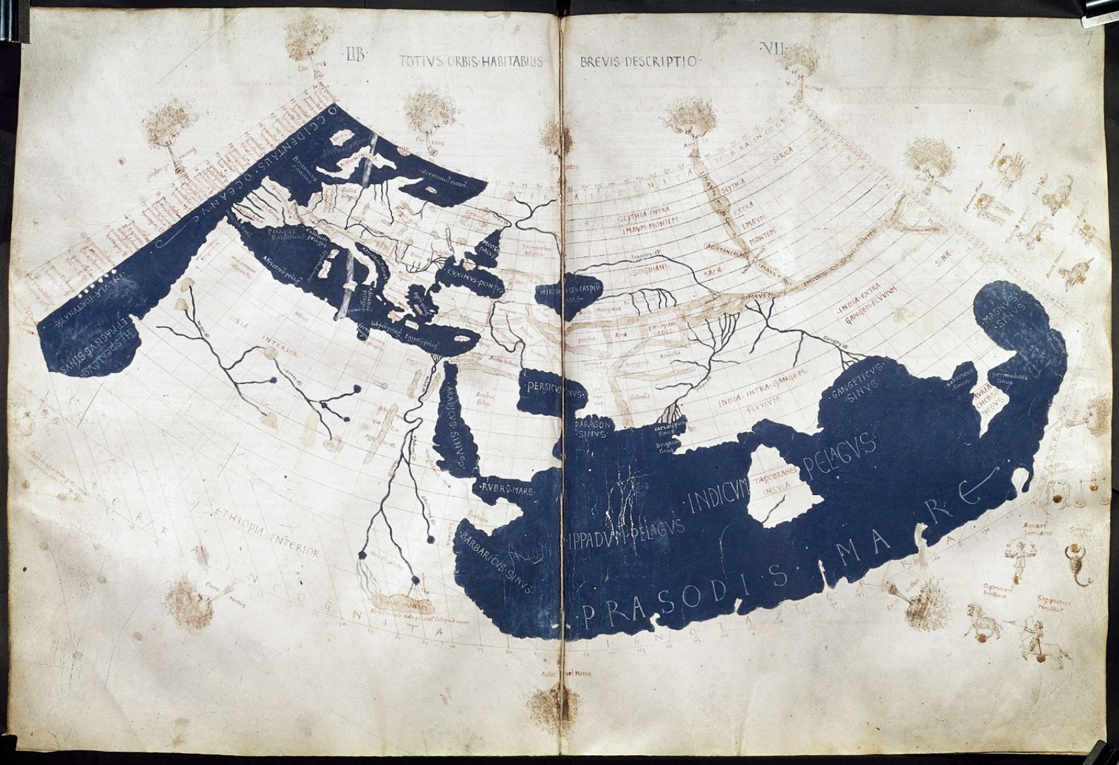
The decision to draw linear borders, though, was a product of a specific kind of groundwork that had been laid out in Europe during the period of the Renaissance in the 14th and 15th centuries, characterised by a renewed interest in classical antiquity and unprecedented progress in the spheres of arts, science, literature, and philosophy. It was during this period that the European world encountered the work of the Egyptian astronomer of Greek descent called Ptolemy. His work included instructions for mapping according to the celestial coordinate system of latitude and longitude. The Ptolemaic cartographic grid made possible the linear division of the world. It was exactly what the European settlers needed in America.
It must be noted that Ptolemy had written his geographic treatise sometime in the second century CE, and it had long been known in the Islamic world. It was rediscovered by Byzantine scholars around 1300, and was made widely available to Western Europe through its Latin translations a century later. “This just shows that one tool or one idea is never enough to drive these huge changes,” says Branch. This is where the colonial encounter became important, coupled with other shifts in Europe, such as internal economic development, increasing scale of military activities, fortifications, use of gunpowder weapons, and more, that pushed towards a centralised rule. In this context, the rediscovery of the mapping tools was suddenly so useful.
In his article, The rise of linear borders in world politics (2018), Goettlich writes that, along with the cartographic knowledge system that Ptolemy’s work produced, came two other epistemic developments in Europe that acted as catalysts for the process of linearisation of boundaries. One was the concept of bounded, self-contained geographical entities that began to be represented in early modern European maps. Then there was the system of international law, which was just as crucial. “The project of international law has, from its origins, been an application of allegedly universal reason on the global scale,” he writes. “It was a novel solution to the gap between the legal systems of Spain and that of the Native Americans that the Spanish encountered, based not on Christian divine law, but on the universal reasoning ability of humans,” adds Goettlich. It was international law, he suggests, that entitled European powers to draw definite, fixed borders, not only between themselves, but all over the world.
The first such linear division was the Papal Bull issued by Pope Alexander VI, dividing all the newly discovered territories in America between Spain and Portugal with an imaginary line in the Atlantic Ocean. The Treaty of Tordesillas, signed between the two countries a year later, moved that line further west to accommodate Portugal’s interests. Accordingly, Spain comprised all newly discovered territories situated to the west of the line, and Portugal was granted all the land to the east.
Interestingly, in the first half of the 16th century, Spanish explorers discovered that the abstract spaces being claimed through these agreements were inhabited by indigenous people. That is when the systems of international law were used in conjunction with brute force and complex negotiations.
By the early 16th and 17th centuries, when the English and French followed the earlier European settlers to America, the tendency to use linear borders to establish control became well established. The language used in English charters to North American colonies, for instance, typically based their authority claims using lines of latitude and longitude. Branch in his work, gives the example of the 1606 charter of Virginia, which delineated the colony as being all land on the Atlantic coast ‘between four and thirty Degrees of Northerly Latitude from the Equinoctial Line, and five and forty Degrees of the same Latitude.’
Goettlich asserts that the act of creating such linear boundaries in North America was a settler-driven process rather than anything that was directed from the imperial metropole. “A good example of this is the way the Dutch and the English settled New York and New England, respectively,” he says. “The Dutch and English settlers worked out the border between themselves, even when it was never even approved by London.” The imperial metropole, he says, in some cases, did not even recognise each other’s existence or the right to colonise America, and so they did not want to agree on any boundaries. “But the settlers had to, because they were there and had to work out a way of living,” he explains.
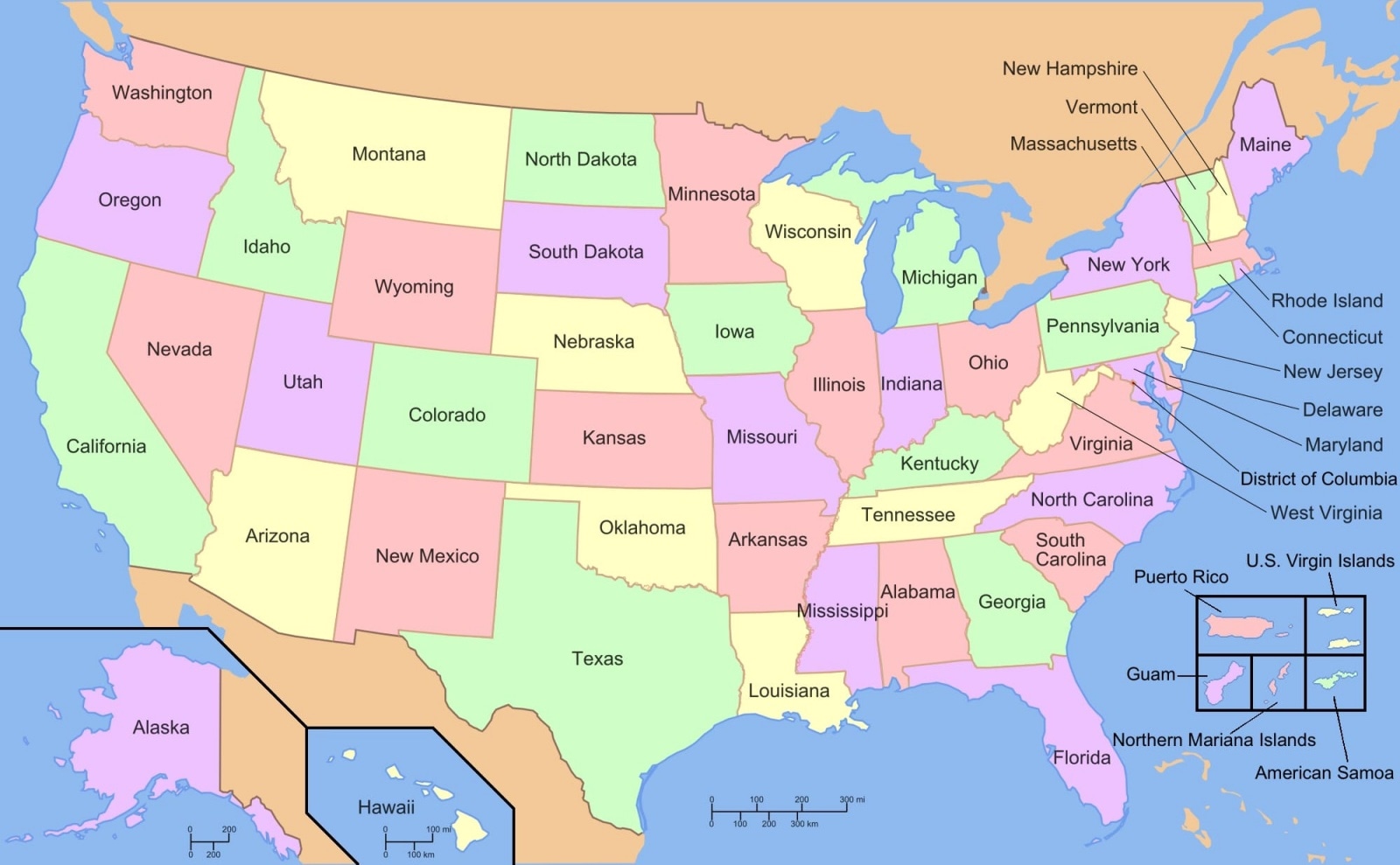
But the cartographic logic of dividing land through linear borders got entrenched in American administration even after its independence in the 1780s. American geographer Matthew Edney points out an interesting difference between the borders of states on the East and West coasts of America. “In the East Coast, you have a lot more irregularly bordered states, whereas as you go westwards you get states which are more rectangular in shape,” he says. In the East, he explains, were different colonial settlers disputing over the placement of their borders. After the American Revolution, the US government expanded westward more systematically. “Consequently, they divided up the American West through a complex process, and they ended up carving it up along the meridian lines to turn them into modern-day states,” Edney says.
Making borders in Europe
Even after borders and maps became a regular feature in the New World, within Europe, most territorial agreements were framed devoid of the language of borders. Scholars agree that borders began appearing in Europe in great numbers only after the Napoleonic conquests of the early 19th century.
A series of treaties between France and its neighbours in the late 18th century implemented linear boundaries. The need to implement linear borders takes off during this period due to greater centralisation efforts on the part of rulers, and consequently, the need to extract as many resources and taxes as possible. “There is also a cartographic mentality that seeps in, especially among the elites and educated who have been surrounded by maps for at least a couple of centuries by now,” says Branch.
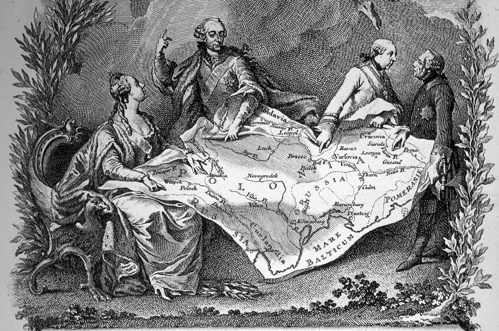
The treaties involved in the partition of Poland among Austria, Prussia, and Russia from the 1770s through the 1790s were yet another instance of early European usage of borders to define territorial divisions. “Like New World colonial charters, these partitions involved the imposition of linear divisions over territories inhabited by people not consulted in the process,” writes Branch in his article.
For the rest of Europe, this process takes off with gusto after Napoleon’s conquests. In fact, scholars have often likened Napoleon’s conquests to colonialism within Europe. It turned France into a dominant European power, with French control being spread over much of continental Europe. Consequently, the territories inside France would be rationalised through extensive land surveys and administrative reorganisation.
The treaties framed after the defeat of Napoleon were marked by a stark difference in their language from those in the previous eras. As Branch notes, “In sharp contrast with a century prior, territory was divided linearly, with those lines of division described in careful geographic and cartographic terms. Authority was now defined exclusively by its boundaries, and places within those boundaries were implicitly claimed.”
One might ask why these new forms of boundaries were found necessary to be used in Europe, where centuries of custom had for long determined territorial authority. The answer, writes Branch, is the usefulness of the new arrangements to rulers seeking to claim and impose authority on spaces both near and far. “European rulers quickly found some of their new colonial ideas — and technologies of power — useful enough that efforts were made to apply them within Europe,” he writes.
Borders and Partitions in South Asia
Despite the widespread use of cartographic systems to draw borders in America, and later in Europe, the colonial authorities chose not to impose them upon the Indian subcontinent upon their arrival. Instead, they chose to adopt the existing territorial divisions that had been framed by the Mughals and other local powers. This by itself was one of the biggest differences between the ways in which the Europeans encountered the new territories in America and those in India.
Edney explains in an interview that colonisers in North America paid little attention to indigenous populations. Goettlich echoes similar thoughts as he says that in America, there was a total lack of recognition of existing polities. “Whereas in India, the British claimed they were preserving an existing political situation and replacing the Mughal emperors,” says Goettlich.
Consequently, the colonial strategies of border making drew heavily upon what the Mughals had already done. “Initially, the British were tied to just a few factories within established ports,” says Edney. “Later, as they started expanding, first in the south and then in Bengal, they largely took over the Mughal-derived systems of territorial management.” Even when they did draw lines to separate the major presidencies, it was largely a secondary exercise. The primary territorial divisions were the list of loosely defined districts drawn up by the local powers for taxation purposes.
The other great difference between the American and Indian colonial experience was that the border-making process in the former involved several petty negotiations among the various European powers. In India, on the other hand, apart from minor regions such as Portuguese Goa, the British were, in essence, marking their territories in consultation with the local powers. “One needs to remember that a fundamental aspect about British India was the fact that large parts of South Asia were ruled indirectly by the British, while it continued to remain under the direct authority of the native princes,” Edney argues.
Even when cartographic principles were not being used to draw borders in colonial India, the use of maps was extensive. As Edney notes in his book, Mapping an Empire (1997), “Imperial British India was far more dependent on maps than early imperial Rome had ever been.” This, he writes, was mainly due to the steady expansion of map literacy in Europe since 1450. Consequently, in India, cartography was used more for gathering information about the subcontinent, rather than for drawing lines.
“The one time that the British could use cartographic logic was the Partition,” notes Edney. “But they don’t, because the cartographic logic had nothing to do with South Asian governmental logic.” The Partition, he says, was mostly based on census data regarding majority Hindu and majority Muslim districts, and thereafter the decision was more about how to apportion these districts so that we have, on one hand, a continuous territory with majority Muslims and another with majority Hindus and Sikhs. The precise borders between these territories remained relatively loose and porous for a long time and were fixed through wars and political negotiations in subsequent years.
Though devoid of cartographic logic, the Partition drew upon the previous colonial practices of imposing linear borders on alien territories. As Branch argues, by the time of the 1947 Partition, political borders were so deeply embedded in the colonial psyche that there was never going to be a question of whether we draw a line. “The only question was, where do we draw the line?” he says.
And the borders never really disappeared long after colonialism. “It became the way in which we saw the world,” adds Branch.
Those arguing in favour of a bordered world have often stated that these lines of political division have enabled more efficiency in terms of trade and taxation. At the same time, though, territorial borders have given rise to some of the bloodiest conflicts in human history. “Borders,” says Branch, “are a route for violence to emerge that would otherwise not exist.” He adds, “You could not have had that kind of nationalist attachment to territory without this kind of mapped cartographic notion of the world.”
Further reading:
Matthew H. Edney; Mapping an Empire: The geographical construction of British India, 1765-1843; University of Chicago Press; 1997
Jordan Branch; Colonial reflection and territoriality: The peripheral origins of sovereign statehood ; European Journal of International Relations; 2011
Jordan Branch, The Cartographic State: Maps, territory, and the origins of sovereignty; Cambridge University Press; 2013
Kerry Goettlich; The rise of linear borders in world politics; European Journal of International Relations; 2018


