


© The Indian Express Pvt Ltd
Tags:
The European Space Agency’s (ESA’s) new mission, which will map the world’s forests, will launch later this month. Known as the Biomass mission, it will provide information about the state of the planet’s forests and how they are changing, which will help expand the knowledge about the role forests play in the carbon cycle.
The mission will lift off on April 29 aboard the Vega C rocket from Europe’s spaceport in French Guiana. It will be placed in a sun-synchronous orbit (SSO) — a type of orbit in which satellites are in sync with the Sun — at an altitude of around 666 km.
The Biomass is ESA’s seventh Earth Explorer mission. Under the Earth Explorer programme, the space agency has launched satellites to observe different aspects of the planet’s system.
Forests are an essential part of the world’s carbon cycle as they store huge amounts of carbon. Scientists estimate that forests absorb around 16 billion metric tonnes of carbon dioxide (CO2) per year, and currently hold 861 gigatonnes of carbon in their branches, leaves, roots, and soils.
However, there is a lack of forest above-ground biomass — the total mass of living organisms located above the forest vegetation — and forest height data on a wide geographical scale. As a result, there is a limited understanding of the state of the forests, their contribution and impact on the carbon cycle and climate. The primary aim of the Biomass mission will be to tackle this knowledge gap.
Importantly, the mission will also allow scientists to more accurately measure how carbon levels are changing as humans continue to cut down trees and increase CO2 levels in the atmosphere. In 2023, there was a loss of 3.7 million hectares of tropical forests, equivalent to around ten soccer fields of forest lost every minute, according to a report by the World Resources Institute. “This forest loss produced roughly six percent of estimated global carbon dioxide emissions in 2023,” the report said.
Simonetta Cheli, director of Earth Observation Programmes for ESA, told the Observer, “We need to know the health of our tropical forests… We need to know the quality and diversity of its vegetation and the amount of carbon stored there. To get that information we are going to create 3D images of them — from the top of the forest canopy to the roots of its trees.”
Beyond forest monitoring, the Biomass mission will observe the movement of ice sheets in Antarctica, and generate digital models of terrains covered by dense vegetation.
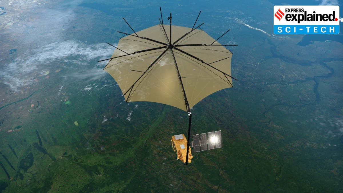
To fulfil its objectives, the mission will use a synthetic aperture radar (SAR) — a satellite imaging technique which uses radar waves to map the Earth’s surface. This SAR sensor will operate in the long-wave P-band frequency range, with a wavelength of 70 cm. Therefore, unlike other shorter-wave SAR sensors, the P-band SAR will be able to peer down through forest canopies to assess how much carbon is stored on the floor and branches of the trees in the world’s forests and to assess how levels are changing. The sensor will also estimate the amount of forest biomass.
Notably, Biomass is the first satellite in the world to host a P-band SAR. The satellite is fitted with a huge 12 m antenna which will be deployed as it begins its sweep over the Earth.
Shaun Quegan, a researcher at Sheffield University (England) and the head of the Biomass science team, told The Guardian, “What the mission will do, effectively, is weigh the forests it studies… We know half that weight must be made up of carbon. So we are going to be able to weigh the carbon content of the world’s… forests from space and, crucially, work out how much these are changing over time. We will then know the balance of carbon that is flowing to and from the atmosphere. That is enormously important.”
The satellites launched under this programme are meant to provide essential information about Earth’s interior, cryosphere (frozen parts), hydrosphere, atmosphere, ionosphere (home to all the charged particles in the atmosphere) and land surface.
The first spacecraft — the gravity field and steady-state Ocean Circulation Explorer (GOCE) mission — took off in 2009 and worked till 2013. The mission helped further research in areas of ocean circulation, physics of Earth’s interior, etc.
The most recent one was the Earth Cloud Aerosol and Radiation Explorer (EarthCARE) mission, which was launched in May 2024. It contributes to a better understanding of Earth’s radiative balance in climate, among other things.


