


© The Indian Express Pvt Ltd
Tags:
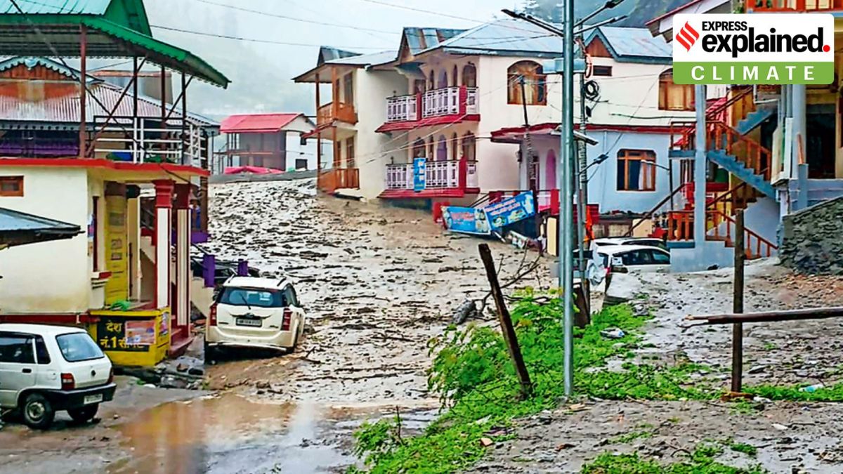
Uttarkashi flash floods 2025: At least four people died after flash floods and mudslides swept through Dharali village in Uttarkashi district, Uttarakhand, on Tuesday afternoon. Several buildings, shops, and hotels were damaged.
Flash floods are not uncommon in the upper hilly areas of Uttarakhand as they are often triggered by a cloudburst — a localised but intense rainfall activity. However, a cloudburst, in a technical sense, did not lead to flash floods on Tuesday, though most parts of the state received heavy rainfall over the past three days.
The primary reason is the topography of the area, where heavy rainfall often results in landslides, sending mud and concrete into the rivers. These materials flow down with great force, accumulating momentum on the way, leading to flash floods downstream.
Uttarkashi district is located at a high elevation ranging between 800 and 6,900 metres above mean sea level. Large geographical areas are covered with snow throughout the year, and there are glaciers in many parts of the district.
It has the upper reaches of the Ganga and Yamuna rivers, and contains their snowbound source region near Gangotri and Yamunotri respectively.
There are also a series of high ridges, perennial rivers, and valleys in Uttarkashi. The rugged topography of the district features sharp undulations due to high mountains, narrow valleys, and deep gorges.
The land slopes steadily towards the southwest, where the elevation in some valleys dips sharply — by as much as 800 metres.
How much rainfall does Uttarkashi receive annually?
Since a large part of the district is situated on the southern slope of the Himalayas, monsoon currents generally penetrate through deeply trenched valleys. Rainfall is at its maximum during the southwest monsoon season (June to September), particularly in the southern part of the district.
Uttarkashi receives about 1,289 mm of rain on average in a year. Past records show that the highest annual rainfall of 2,436 mm (189 per cent above normal) was recorded in 1969. July is the district’s wettest month, during which it receives about 312 mm of rain on average.
The district is prone to thunderstorms, which occur frequently in the hilly areas.
The topography, combined with the continuous rainfall over the past few days, probably created the perfect scenario for triggering mudslides, debris slides and flash floods as experienced on Tuesday.
The increase in rainfall intensity owing to climate change has added to the pressure on glaciers and snow accumulated during the winter months. As a result, the deglaciation rate in the area has accelerated.
Rainfall of any intensity, if continuous, recorded over such high altitudes where Uttarkashi is located, can be disastrous. That is because this region is built on layers of mudslides over the past several centuries.
Uttarkashi district is situated along the southern Himalayan slope, where there is limited vegetation and no significant obstruction. Mild triggers such as rainfall or earthquakes can cause loose moraine and soil to easily slither downhill, swallowing homes and roads along its path.
A cloudburst has a very specific definition: Rainfall of 100 mm or more in an hour over a roughly 10 km x 10 km area is classified as a cloudburst event, according to the India Meteorological Department (IMD).
IMD’s 24-hour rainfall data as of 8.30 am on Tuesday said Uttarkashi had received 2.7 mm. Also, between 8.30 am and 4.30 pm, rainfall across various meteorological stations in Uttarkashi was well below the threshold defined for a cloudburst, IMD data show.
There has been heavier rainfall in other parts of Uttarakhand over the last three days. For instance, the 24-hour rainfall recorded over the plains of Haridwar was 300 mm on Tuesday.

