


Stay updated with the latest - Click here to follow us on Instagram
© The Indian Express Pvt Ltd
Tags:
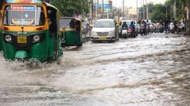
Following the earliest advancement of Southwest (SW) monsoon since 2009, heavy to very heavy rainfall is likely across Karnataka over the next few days.
According to the India Meteorological Department, the SW monsoon that entered parts of coastal Karnataka on Saturday, covered some more parts of the state in the interior Karnataka region. On Sunday, the Northern Limit of Monsoon (NLM) was passing through Belagavi, Haveri, and Mandya in Karnataka, with Bengaluru expected to be covered by the monsoon over the next couple of days.
During normal years, the NLM lies below the state of Kerala on May 25, as the onset of monsoon over Kerala is generally between May 28 and June 1.
Meanwhile, heavy rainfall continued to lash coastal Karnataka and Malnad districts of South Interior Karnataka on Sunday. Some parts of coastal districts, adjoining the Western Ghats, received very heavy rainfall in excess of 100 mm. Other parts of the state, such as Bengaluru, received around 15 to 20 mm, as overcast conditions brought down summer temperatures.
A red alert for heavy to very heavy rainfall has been issued for South Interior Karnataka till May 27, after which an orange alert will be in effect for Karnataka till the end of May.
Stay updated with the latest - Click here to follow us on Instagram

