


Monsoon LIVE: Meanwhile, in Rajasthan, seven people have died over the past two days in rain-related incidents while the meteorological department has warned that thunderstorm and dust storm are “very likely” over 20 districts of Uttar Pradesh, mostly in eastern parts, during the next 24 hours. The maximum temperature in several parts of northern India remained above normal on Thursday, including the national capital Delhi, where the maximum temperature was registered at 41.4 degrees Celsius, a notch above the season’s average. The Met office in Delhi has forecast overcast skies with a possibility of thundery developments today. The maximum and minimum temperatures are expected to hover around 40C and 30C respectively, the weatherman said.


LIVE UPDATES: Monsoon to hit Mumbai today, heavy rain predicted in the city
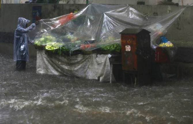
(Express Photo by Pradip Das)
monthly limit of free stories.
with an Express account.
To warn people about the dangers of wading or swimming in the sea during the monsoons, red flags will be put at beaches in Goa, a PTI report said. The Goa government shuts down beaches for swimming and other water sports activities during the monsoon from June to August each year as a precautionary step. This includes a 61-day fishing ban that started from June 1 and ends on July 31.
Four persons, including a girl, were killed when lightning struck them in two separate incidents in Jharkhand, police said. A man and his daughter were working in their field at Ramtunda village of Chatra district when lightning struck them during rain, killing them on the spot, a police officer said. In another incident, two persons were killed when lightning struck near Khetko village in Bokaro district this afternoon.
Light rains brought down day temperatures at a few places in Rajasthan, even as Churu was the hottest place in the state recording a high of 45.5 degrees Celsius.
Heavy rains lashed Shimla and adjoining areas this afternoon, causing drop in day temperature. The local meteorological office has warned of thunderstorm with gusty winds at isolated places in Shimla, Solan, Sirmaur, Mandi and Kullu districts on Saturday and Sunday.
The IMD once again alerted residents on India's west coast about the possibility of "extremely heavy rainfall" in parts of the region during next 2-3 days. The IMD said the monsoon has advanced to parts of central Arabian Sea, Goa, Karnataka, Rayalaseema region and coastal Andhra Pradesh, parts of south Konkan, south-central Maharashtra, Marathwada, Vidarbha, south Chhattisgarh, south Odisha, Telangana, and west-central and north Bay of Bengal. "Increased rainfall activity over coastal Karnataka, Goa and south Maharashtra is likely to continue till June 10. It is very likely to extend to north coastal Maharashtra, including Mumbai, from tomorrow. Extremely heavy rainfall at isolated places in these regions is very likely during this period," the department said.
Increased rainfall activity over coastal Karnataka, Goa and south Maharashtra is likely to continue till June 10. It is very likely to extend to north coastal Maharashtra, including Mumbai from tomorrow. Extremely heavy rainfall at isolated places in these regions is also very likely during this period. The rainfall activity over these regions is likely to reduce from June 12.
Conditions are very likely to become favorable for further advance of Southwest Monsoon into most parts of Arabian Sea, remaining parts of Maharashtra, some parts of south Gujarat region, southern parts of Madhya Pradesh, some more parts of Chhattisgarh and Odisha, some parts of West Bengal and Sikkim, remaining parts of Northeastern States and Bay of Bengal during the subsequent 48 hours.
Conditions are favorable for further advance of Southwest Monsoon into some more parts of Central Arabian Sea, Maharashtra (including Mumbai), Chhattisgarh and Odisha and remaining parts of Coastal Andhra Pradesh during next 24 hours.
Southwest Monsoon has further advanced into some more parts of Central Arabian Sea, remaining parts of Goa, Karnataka and Rayalaseema, some parts of south Konkan, south Madhya Maharashtra, Marathwada, Vidarbha, south Chhattisgarh and south Odisha, entire Telangana, most parts of Coastal Andhra Pradesh, remaining parts of West Central Bay of Bengal and most parts of North Bay of Bengal. The Northern Limit of Monsoon (NLM) passes through Lat. 17°N/ Long. 60°E, Lat. 17°N/ Long. 70°E, Ratnagiri. Solapur, Nanded, Adilabad, Bailadila, Malkangiri, Kalingapatnam, Lat. 21°N/ Long. 90°E, Agartala, Lumding, north Lakhimpur and Lat. 29°N/ Long. 95°E.
Angry Lucknow residents questioned the rationale behind the government's pre-monsoon jobs. Internet connectivity was also been hit at some places due to waterlogging or snapping of the optical fibre cable.
IN Lucknow, as roads were dug up for sewer pipeline laying to improve the drainage system ahead of the monsoon, many low lying areas turned into pools and people had to wade through them.
There were heavy traffic snarls at many places like Hazratganj, Alambagh, Narahi, Indiranagar, Aliganj and Gomtinagar with office goers and commuters facing a tough time. Power outages were also reported from many localities here.
As heavy rains lashed Lucknow for more than two hours, youngsters took to streets and drenched themselves in the first rains of the season. The Regional Met office said these were pre-monsoonal showers and the weather would remain the same for the next 24-hours. The skies would be overcast with intermittent rains in Lucknow and eastern Uttar Pradesh.
Kerala saw active to vigorous Monsoon conditions with Kannur recording 116 mm of rain, Kozhikode 90 mm, Thiruvananthapuram 46 mm, Kochi 44 mm.
Rain, thundershower with strong gusty winds would occur over Bankura, Barddhaman, Birbhum, Murshidabad, Paschim Medinipur and Puruliya districts of West Bengal during the next 6 hours.
During the last 24 hours Southwest Monsoon remained vigorous over Coastal Karnataka with Mangalore recording 158 mm, Honavar 147 mm, and Madikeri seeing 101 mm.
During the last 24 hours, temperatures soared above the 45-degree mark in most parts of Rajasthan. Severe heatwave conditions prevailed in some pockets of Rajasthan. Heatwave conditions have abated from Madhya Pradesh. Though the temperatures were soaring very high. At present, Bundi in Rajasthan is the hottest city in India with a maximum temperature of 47.2°C.
In the past 24 hours, heavy rains with very heavy spells at few places were witnessed over Karnataka, Kerala, Andaman and Nicobar Island and Maharashtra. In fact, many parts of Bihar has also recorded widespread heavy rainfall activity. The northeastern states are also continuing to record good rainfall activities.
At present, Shirali in Karnataka is the rainiest place in India with 194.0 mm of rainfall.
A low pressure, being formed over the Bay of Bengal, will trigger the advance of Southwest Monsoon in West Bengal and Odisha from June 9, the Meteorological department said here Thursday. The low pressure is likely to intensify into a depression by Saturday and move north-northwestwards across West Bengal and Bangladesh coasts, the MeT department said and forecast isolated heavy rains in West Bengal and parts of Odisha from June 9.
The South West Monsoon is currently active over Kerala with heavy rains lashing the southern state. Widespread rainfall is likely to continue in the state during the next five days, K Santosh, in-charge of India Meteorological Department, Thiruvananthapuram, said.
In eastern India, the Meteorological department in Kolkata said a low pressure being formed in the Bay of Bengal will advance the Southwest Monsoon in West Bengal and Odisha from June 9. The low pressure is likely to intensify into a depression by Saturday and move north-northwestwards across West Bengal and Bangladesh coasts, the MeT department said. It warned fishermen not to venture into the sea along these areas and Odisha coast from June 8 till further notice.
Srinagar, the summer capital of Jammu and Kashmir, registered a maximum temperature of 28.8C and a minimum of 15.9C on Thursday.
Residents of Punjab and Haryana experienced largely normal temperatures on Thursday. Hisar and Bhiwani in Haryana registered a maximum temperature of 43.9C and 43.1C. Amritsar and Ludhiana in Punjab registered a maximum of 40.5C and 39.5C, the local weather office said. Chandigarh, the joint capital of the two states, registered a maximum temperature of 39.5C.
The Met office in Delhi has forecast overcast skies with a possibility of thundery developments today. The maximum and minimum temperatures are expected to hover around 40C and 30C respectively, the weatherman said.
The maximum temperature in several parts of northern India remained above normal, including the national capital Delhi, where the maximum temperature was registered at 41.4 degrees Celsius, a notch above the season’s average, on Thursday.
In Himachal Pradesh, sporadic rains lashed a few places in the state, including Shimla, which is battling a water shortage for a fornight. The sky remained heavily overcast on Thursday. The local MeT office has warned of thunderstorm with gusty winds in lower and mid hills today and tomorrow.
“Heavy to very heavy rainfall at a few places with extremely heavy at isolated places over North Goa and South Goa district of the State is expected on June 8. Heavy to very heavy rainfall at few places on June 9 and 10 and heavy rainfall is likely to occur at isolated places on June 11,” the IMD weather forecast states.
IMD-Goa Director M L Sahu said that on Friday, there will be extremely heavy rainfall and we have issued a red alert. 95 per cent rainfall is expected in the State. Monsoon will spread across Konkan region and Maharashtra in coming days. He said that there was no large change in maximum temperatures and they were normal. The highest maximum temperature of 33 degrees Celsius was recorded at Panjim and Mormugao.
The Met office had on Thursday had warned that thunderstorm and dust storm are “very likely” over 20 districts of Uttar Pradesh, mostly in eastern parts, today. The districts include Unnao, Farukhabad, Kannauj, Varanasi, Gorakhpur, Ballia, Ghazipur, Kushinagar, Mau, Deoria, Maharajganj, Balrampur, Shrawasti, Lakhimpur Kheri, Pilibhit, Rampur, Moradabad, Bijnor and Bareilly, it said.
The Met office in Jaipur has forecast light rains in the eastern part of the desert today. The western parts remained dry with Churu being the hottest place at 47C. Heatwave conditions prevailed in a few places in western Rajasthan.
Meanwhile, in Rajasthan, seven people have died over the past two days in rain-related incidents, the police said today. Of the seven, three died when a portion of their house collapsed due to strong wind and rain on Tuesday evening.

Rain lashed parts of Lucknow Friday morning. See pics (ANI photos)
As per the IMD forecast, there is a possibility of very heavy rainfall in Ratnagiri, Sindhudurg, Mumbai, Thane, Raigad and Palghar districts on June 9. There is a similar forecast for the six districts of Konkan region, including Mumbai, and surrounding areas on June 10 and 11.
The BMC statement also said, "The education officers monitoring school premises in all 24 administrative wards have been asked to keep shelter schools open 247. Dewatering pumps will be kept ready and flood-prone spots will be monitored closely during the heavy rain period."
In addition to this, six Flood Rescue Teams of Mumbai Fire Brigade will be posted at the Regional Command Centres and emergency support functions like BEST (bus transport system), police, traffic police and education officers have been alerted.
On the steps being taken, the BMC said three teams of National Disaster Response Force (NDRF) will be stationed at Parel, Mankhurd (for eastern suburbs) and Andheri Sports Complex (for western suburbs). They are equipped with walkie-talkies and flood rescue material. Besides, Navy personnel will be deployed in Colaba, Worli, Ghatkopar, Trombay, Malad for flood rescue if required, the BMC release said.
“Leaves of all the senior officials, including Deputy Municipal commissioners (DMCs), Assistant Commissioners (AMCs) and heads of departments have been cancelled and they have been directed to be available in their headquarters on June 9 and 10 (Saturday and Sunday),” BMC said.
With the IMD predicting “heavy to very heavy” rainfall along the Maharashtra coast, including Mumbai, over this weekend, the Mumbai civic body is preparing itself to prevent and tackle monsoon-related disasters. The Brihanmumbai Municipal Corporation (BMC) administration has taken a number of precautionary measures to tackle any eventuality in view of extremely heavy rainfall warning by the India Meteorological Department (IMD) from June 9 to 11, a statement issued by the civic body said.
Within 45 minutes of moderate rainfall on Thursday, several parts of central Mumbai were waterlogged, especially in chronic flooding spots like Hindmata in Dadar, Dadar TT circle, Elphinstone Road, and parts of Parel. The railway tracks near Sion station were also inundated in the showers.
The India Meteorological Department’s Colaba observatory recorded 27.6 mm rainfall till 5.30 pm while the Santacruz observatory recorded 39 mm rain during the same period. The figures remained the same in the IMD Mumbai’s 8.30 pm report.
During about an hour of moderate rain, there was water logging in parts of central Mumbai, especially in places like Hindmata in Dadar, Dadar TT Circle, some areas on Elphinstone Road and parts of Parel between 11.30 am and 12.30 pm. The water started receding after 2.30 pm. Traffic police officers diverted traffic around Hindmata after water levels rose to about 1.5 feet. Traffic was also diverted from King Circle and Sion Road no. 24.
On the WR, commuters posted pictures of water leakage in the Air-Conditioned (AC) local train on social media after it rained in the morning. Officials from WR said they got it redressed. The Brihanmumbai Electric Supply and Transport (BEST) diverted buses on 20 routes in Sion, King Circle, Hindmata and Bandra due to waterlogged streets.
Also, airlines, including Vistara and JetAirwayss, informed the passengers to make it early to the airport due to congestion on the Western Express Highway and other roads leading to the airport. Officials said air traffic congestion continued at the airport till 5 pm. In railway stations, including Parel and Elphinstone Road, officials from the Maharashtra Security Force (MSF) and Railway Protection Force (RPF) managed the crowd. “We have posted guards at the beginning and landing of the staircase to ensure crowds formed queues while climbing up or getting down the stairs,” an MSF official said.
At Chhatrapati Shivaji International Airport (CSIA), officials from the Mumbai International Airport Limited (MIAL) that manages the airport said they had to suspend closure of the main runway for maintenance because of the weather. The runway was supposed to be shut between 1.45 pm and 3.45 pm. “No major effect on the flights was witnessed. However, a Jet Airways flight, 9W-117, from London to Mumbai and flying with 343 passengers was diverted to Ahmedabad before the monsoons hit the city,” a MIAL official said on Thursday.
Train services in the suburban section in Mumbai reported delays on Thursday. While services on the Central Railway (CR) were delayed by 10-15 minutes, trains on the Western Railway (WR) ran as per schedule. Water-logging was seen on the tracks near Sion and Thane stations. “Despite heavy rains, the suburban train services were not affected,” a senior WR official said.
In the wake of the IMD warning, the Mumbai civic body is preparing itself to prevent and tackle monsoon-related disasters. The Brihanmumbai Municipal Corporation (BMC) said three teams of National Disaster Response Force (NDRF) will be stationed at Parel, Mankhurd (for eastern suburbs) and Andheri Sports Complex (for western suburbs). They are equipped with walkie-talkies and flood rescue material.
At least three flights, including a Jet Airways flight from London, were diverted and local train services were disrupted after heavy rains lashed Mumbai on Thursday. This year, the monsoon made an early onset — by three days — over the Kerala coast on May 29.
Mumbai received heavy showers in the early hours of Thursday as well. According to the IMD, the Santacruz observatory recorded 18.8-mm rainfall and Colaba recorded 35.8-mm rainfall between 4 am and 8.30 am. Meanwhile, temperatures also dipped on Thursday with the Santacruz observatory recording maximum temperature at 29.2 degrees, four degrees below normal, and minimum temperature at 25.2 degrees, one degree below normal. Read More
The weather department recorded 39-mm rainfall at Santacruz observatory and 27.6-mm rainfall at the Colaba observatory on Thursday. “Monsoon has not arrived in Mumbai as of now and the rains in the city and adjoining areas since morning are pre-monsoon showers,” K S Hosalikar, deputy director general, western region, said on Thursday.