


© IE Online Media Services Pvt Ltd
Tags:

India-Pakistan Sir Creek Border Dispute Explained: Union Defence Minister Rajnath Singh on Thursday (October 2) warned Pakistan over the Sir Creek region, reiterating India’s firm stance on the subject of its territorial integrity. The comments come at a time when India-Pakistan tensions are already heightened after the Pahalgam attacks and Operation Sindoor, also bleeding into the recently concluded Asia Cup cricket tournament.
The minister said any Pakistani misadventure in this area would invite a severe Indian response, one capable of “changing both history and geography”.
Sir creek was originally named ‘Ban Ganga’ and got its present name after a British official. The creek is a 96-km tidal estuary along the India-Pakistan border, located between Gujarat in India and Sindh in Pakistan.
It flows into the Arabian Sea and lies at the heart of a prolonged dispute over maritime boundaries, control of natural resources, and strategic dominance.
The Sir Creek dispute stems from the varying interpretations of colonial-era boundary lines by both the nations. The matter is compounded by the changing course of the Indus over the years.
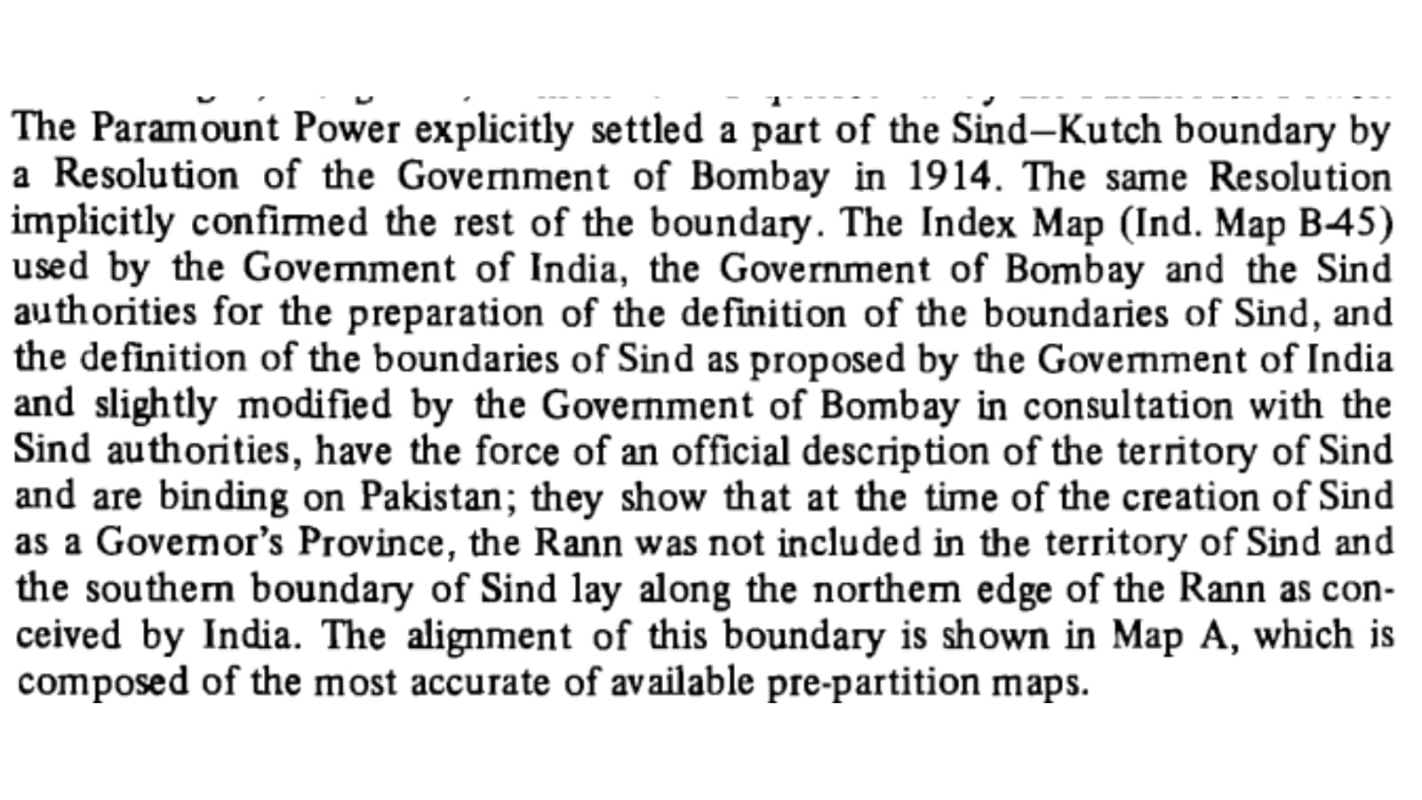
The dispute was first officially addressed by the Government of Bombay in 1914. It resolved a dispute between the Sindh and Kutchh regions in the then undivided India. The conflict arose next nearly four decades after the Partition and gained steam after the 1965 Indo-Pak war.

After Pakistan was defeated in the 1965 war, the Rann of Kutchh (and Sir Creek) border dispute went to a UN Tribunal. Under the 1965 ‘Agreements for the Determination of the Border’, both nations agreed to the establishment of a tribunal to give a final determination of the boundary.
A study by the Durham University says the tribunal agreed to 90% of India’s claims in the Rann of Kutchh region and conceded only small sectors to Pakistan.
According to The Indo-Pakistan Western Boundary Tribunal’s report of 1968, “This agreement leaves out of the matters submitted to the Tribunal the portion of the boundary along the blue dotted line, as depicted in Indian Map B-44 and the Pakistan Resolution Map, as well as the boundary in the Sir Creek.”
While Pakistan cites a 1914 resolution and argues that even if viewed as a marsh, swamp, or desert, the Rann of Kutchh acts as a wide natural barrier, which should equitably be divided into two halves by a median line, India cites a revision of a resolution in 1925 to assert its claims.
It directly impacts maritime boundary delimitation and Exclusive Economic Zones (EEZs) in the Arabian Sea. EEZs or exclusive economic zones are areas of the ocean, generally extending 200 nautical miles (230 miles) beyond a nation’s territorial sea, within which they have jurisdiction over both living and non-living resources.
Control over this estuary influences access to key sea routes, including the “road to Karachi”, as Singh warned, making Sir Creek strategically significant for national security and military planning. Pakistan has escalated its military infrastructure here, prompting India to step up its defences, including the Border Security Force and Navy.
What was the 1914 resolution?
The 1914 Resolution of the Government of Bombay played a crucial role in establishing the boundary framework that excluded Sir Creek from the later arbitration. However, the resolution addressed the boundary dispute between Sindh and Kutch at the western end of the Rann, particularly around Sir Creek.
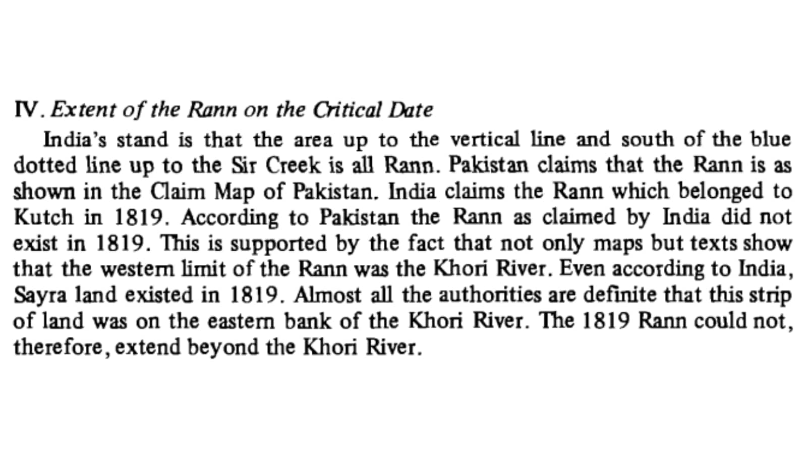
The specific area in dispute at present is the northern half of the Great Rann of Kutchh. It was then considered a “no man’s land” and the boundary between Sindh and the Indian States was “conterminous”, or shared. The Rann of Kutch is a “peculiar surface, most akin to a marsh or swamp”, the tribunal said.
What have India and Pakistan argued?
The tribunal examined extensive historical evidence dating back to the Treaty of 1819 between the East India Company and the Rulers of Kutch. Both parties agreed that Kutch’s boundary had remained unchanged since this treaty.
India claimed a well-established boundary running roughly along the northern edge of the Rann of Kutch, as shown on pre-partition maps, needing only demarcation.
Pakistan argued for application of the “median line principle,” contending that the Rann should be divided equally between the two countries based on international law principles governing inland seas and lakes.
India argued that the tribunal’s task was to ascertain where the boundary was, not where it ought to be according to abstract principles. India maintained that the Rann was land, not a water feature, and that no general rule required water boundaries to follow median lines
India maintained that Kutch’s territorial extent had remained unchanged since the Treaty of 1819 between the East India Company and the Rulers of Kutch. The Rann was traditionally part of Kutch territory even before 1819.
India relied heavily on Survey of India maps as conclusive evidence, arguing that these maps were produced by the expert department of the Government of India and were approved by all authorities from the Secretary of State to local commissioners. It emphasised that these maps had “stood the test of time for nearly a century” and were regarded as authentic for all purposes, including boundaries.
Pakistan contended that the border ran roughly along the 24th parallel, which represents the northern border between the two nations in the Rann of Kutchh, involving approximately 3,500 square miles of disputed territory.
Sir Creek holds considerable economic importance despite it largely being an uninhabited marshland. The region is believed to contain hydrocarbon reserves like oil and gas, which both nations aim to exploit under the 1982 United Nations Convention on the Law of the Sea (UNCLOS).
Moreover, the creek supports vital fishing grounds, which is crucial for the livelihoods of local fishermen from Gujarat and Sindh. However, the absence of a clear boundary results in frequent arrests of fishermen who inadvertently cross into the other country’s waters. This only adds to the tensions and disruption of livelihoods for the people.
Sir Creek is also part of the larger Indus River Delta ecosystem, which hosts unique mangroves and marine biodiversity reliant on tidal patterns.
Environmental changes, including the impact of Pakistan’s discharge of saline and industrial water through the Left Bank Outfall Drain (LBOD) canal project, are viewed by India as violations of the Indus Waters Treaty. Rising sea levels and shifting channels continue posing security and economic challenges to both India and Pakistan.
The dispute remains unresolved till date. Both nations conducted hydrographic surveys and exchanged data and charts in 2007, but a concrete decision is yet to be reached. After the 1984 Simla Agreement, it is not possible for a third party to intervene either.
In case India and Pakistan agree to an adjudication by the International Court of Justice (ICJ), both will have to give up their respective claims and submit to independent scrutiny by the ICJ and accept its decision as binding. This seems unlikely as either is unlikely to give up its claim.
In such a situation, the only way out of this border dispute is through bilateral dialogues and agreement.
Rajnath Singh’s remarks on Thursday at the Bhuj military base brought to the fore Pakistan’s increased military presence in Sir Creek. Singh said India is ready to hit back decisively, as in ‘Operation Sindoor’. He recalled India’s military successes in 1965 and warned Pakistan against underestimating Indian resolve.

