


Stay updated with the latest - Click here to follow us on Instagram
© The Indian Express Pvt Ltd
Tags:

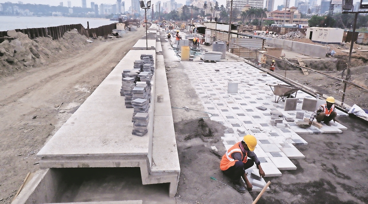
By the end of this year, the Mumbai Coastal Road Project, a 10.5-km-long high-speed corridor that will connect Marine Drive and Worli will be ready for public use. The sprawling concrete pathway being constructed by the Brihanmumbai Municipal Corporation (BMC) is fundamentally going to change how the city travels. PRATIP ACHARYA and SWEETY ADIMULAM report.
The Brihanmumbai Municipal Corp-oration (BMC) planned the Coastal Road on the western side of Mumbai to provide an alternative north-south trunk route to improve mobility along with development of recreational open spaces and greenery.
The entire Coastal Road will be 29.20-km long along the western coastal stretch of Mumbai. The road is being constructed in two phases. The first comprises the 10.5-km-long south section, which will connect Princess Flyover Road with Worli Sea Link. Work on this stretch is currently on. The second phase involves connecting Bandra Sea Link and Kandivali junction. Work on this stretch is yet to commence.
The 10.5-km-long Coastal Road will have two carriageways of four lanes each for north- and south-bound traffic. Besides, each carriageway will have an additional lane for public buses. The highpoint of the project is the 2.07-km-long twin tunnels that will originate in Girgaon and run below the Arabian Sea, adjoining Girgaon Chowpatty, moving northwards from below Malabar Hill. The other end of the tunnels will be at Priyadarshini Park (PDP).

The tunnels were dug using a Tunnel Boring Machine (TBM). The ramps at the entry and exit points are being built using the conventional cut-and-cover method.
Besides giving commuters a world-class travel experience, the Coastal Road is expected to change the western shoreline of Mumbai, with new green spaces, promenades and recreational areas in a space-starved city.
While the average speed on Mumbai’s roads ranges between 21 kmph and 25 kmph during peak hours, motorists will be able to drive at an uninterrupted 80 kmph on the Costal Road.
According to the BMC, the Coastal Road will bring down travel time between Princess Street and BWSL to less than 10 minutes, which at present takes 35-45 minutes during peak hour. The Coastal Road is also set to reduce fuel consumption by 35 per cent, besides bringing down noise and air pollution reducing carbon footprint by 1,826 tons annually.
Significance
The idea of the Coastal Road was first floated in 2012, as an alternative to the Western Express Highway (WEH) to improve north-south connectivity in Mumbai. However, the project started taking proper shape after five years when the Union Ministry of Environment, Forest and Climate Change gave its final nod in May 2017, following which the foundation stone of the project was laid in 2018 at Cumballa Hill.
Now, with the Coastal Road nearing completion, Additional Municipal Commissioner Ashwini Bhide, who is spearheading the project, said that the high-speed corridor will help in the overall development of Mumbai.
“Mumbai has a road network of 2,050 km compared to Delhi’s 28,000 km. As Mumbai is surrounded by the sea on three sides, there is a limit for the city to expand geographically. Even though we have been constructing elevated roads for east-west connectivity, there are several constraints. The elevated roads often eat up space of the carriageways on the roads below. Therefore, when redevelopment takes place, it becomes very difficult to expand the existing roads beyond a limit,” Bhide told The Indian Express.
“The ultimate objective of the MCRP is to decongest the existing roads. Mumbai is linear in shape for which travelling is mostly in north-south direction. Roads offer direct connectivity and the city will be able to maintain its proper pace only when there are improved roads, or else areas that don’t have proper connectivity despite potential and high land value will not be able to flourish,” she said.
Bhide said that the administration has taken a two-fold approach on this — one, expand existing road capacity by tweaking road networks and, second, create additional road networks or alternatives such as Metro rail.
“Still, we will need roads or else how will freight movement happen? Roads also offer direct connectivity that eases the load on existing public transport networks. This is how all cities globally manage transportation and that’s why Mumbai, despite the railway lines and Metro lines, will need robust road connectivity,” she said.
Key aspects, takeaways
Besides promising Mumbaikars 70 hectares of open spaces, the Coastal Road has created its own unique set of records. The 2.07-km-long twin tunnels that will connect Marine Drive with PDP is the country’s first undersea tunnel, with a 1-km stretch in Girgaon passing 17 to 20 metres below the Arabian Sea.
The BMC has built 10 bus bays on the road to cater to the needs of people travelling by public transport. The civic body is also creating three
underground parking lots at Amarsons Garden, Worli and Haji Ali, which will have an overall capacity to accommodate 1,800 cars.
“The idea is to encourage people to use this sea-face. People who may intend to visit the promenade may worry about where to park their cars. These parking lots will solve this issue. As we said, this is not just a high-speed corridor but also patches of open spaces that we are offering to people,” Mantayya Swami, chief engineer of the Coastal Road project, said.
Alongside these, the BMC is also creating 16 pedestrian underpasses (PUPs) between PDP and Worli. Civic officials said these PUPs will be like subways allowing people to access the promenades and bus bays along the Coastal Road.
Current status
The BMC has set a November 2023 deadline for the project. However, civic officials said that while the stretch till Worli Interchange will be ready by then, work on the last few hundred metres, which involves construction of a new bridge, may stretch till May 2024.
“The prospective commissioning date is November 2023 but because of the decision to change the design of the bridge, which was taken two months back, the deadline may get slightly extended,” said Bhide.
“The contractor has chosen his initial designs and it is in the process of approval. Construction is expected to start soon. However, the deadline for that particular portion may get pushed till May next year,” she said.
The new bridge is being built to provide fisherfolk increased span for navigating their boats. Civic officials said the new bridge will be like a ‘Bow-String’ girder bridge.
Though civic officials are confident about the November deadline, keeping in mind the monsoon season ahead, it is likely to get pushed by a few months.
At present, as per BMC’s figures, overall progress of civil works is 72 per cent, which includes 93 per cent of SWD network, 83 per cent of PUPs, 62 per cent of bridges, 60 per cent of interchanges and 28 per cent of road works. The construction of major parts of the promenade, other than the stretch at
Marine Drive, is yet to start. Several ancillary works too are yet to be completed. Work on the proposed parking lots too is yet to start. Civic officials said all these works will be taken up once the main carriageway of the road is ready.
Stay updated with the latest - Click here to follow us on Instagram

