


Stay updated with the latest - Click here to follow us on Instagram
© The Indian Express Pvt Ltd
Tags:
Following the Irshalwadi landslide, the Geological Survey of India (GSI) is set to carry out a fresh survey of the landslide affected region to assess the vulnerability of inhabited hill slopes in the region.
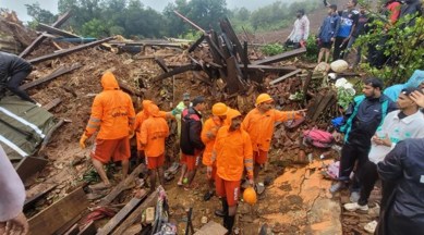
On July 19, the entire Irshalwadi, which was a hamlet on the Western Ghats’ Sahyadri Forest Range in Raigad district, was buried after a landslide which was caused due to incessant rain that lashed the Konkan belt for two weeks continuously. In the incident, nearly 84 lives were lost, with only 27 bodies recovered, and 57 still missing.
In the last ten years, Irshalwadi is the third village in the state to be entirely wiped out by a landslide. Consequently, Maharashtra government officials said that GSI, to assess vulnerability, will survey other villages in the district that are located on slopes and hillocks.
Dr Yogesh Mhase, collector of Raigad district, told The Indian Express on Tuesday, that a team of GSI officials have already visited the spot for inspection following the incident. “GSI members have made preliminary visits to the landslide affected spot. Earlier, the state government had released a list of several villages that are susceptible to landslides. However, many villages around Irshalwadi were not in the list, and our office requested GSI to carry out a fresh survey so that the unmentioned vulnerable villages could be included in the list, as it will help us take preemptive action,” Mhase told The Indian Express.
According to the state government’s disaster management cell, a total of 230 villages and hamlets of Maharashtra are located in landslide prone areas. In Raigad alone, nine villages are situated in a ‘very-sensitive’ zone, while eleven are in a ‘sensitive’ zone.
Speaking to The Indian Express, Prakash Gajbhiye, director of GSI in Pune, said his team visited the spot a day after the Irshalwadi landslide. “We are now planning a survey to study the hill slopes and overall geological components of that region. We can’t comment right now on what caused the landslide but a report on our findings may reflect the probable causes,” Gajbhiye told The Indian Express. “Imagery shows agricultural fields on the foothills in Irshalwadi. Through our survey, we will check the drainage pattern and how the drainage system works there. We will also try to find out if minor landslide incidents took place earlier to get a broader understanding about what triggered the July 19 incident,” he said.
The Western Ghats cover 51 districts and are said to be 150 million years old. The ghats are one of the 34 global biodiversity hotspots, and several rivers and streams that flow through the Deccan plateau region also originate from Western Ghats.
Stay updated with the latest - Click here to follow us on Instagram

