


Stay updated with the latest - Click here to follow us on Instagram
© The Indian Express Pvt Ltd
Tags:
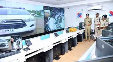
The Greater Chennai Police Tuesday launched Geographic Information System (GIS) mapping of crime zones in the city. Greater Chennai Police Commissioner Shankar Jiwal initiated the project at the Integrated Command and Control Room (ICCR) under the Safe City Programme to include location intelligence to prevent crimes across GCP Jurisdiction.
According to a statement, a special GIS centre has been established at the commissioner’s office. It is equipped with the latest GIS software tools and technologies that help compile data from Crime and Criminal Tracking Network and Systems (CCTNS), daily service registers, daily incident reports and other critical data sets from the Greater Chennai Corporation’s Social Welfare Department.
More than 60,000 crime records between 2016 and 2022 from the CCTNS, daily service registers have been mapped to their precise locations through more than 300 trained police personnel, the statement said.
It added that a comprehensive process of recording the daily incident data had been established and published through a web-based GIS analytical dashboard to visualise and make informed decisions to prevent crimes across the city.
As part of the data compilation activity, the geo-location of around 67,000 cameras installed in critical locations of Chennai from various projects have been plotted on the GIS maps to support officers during the investigation.
These locations include establishments such as women and child support centres, education institutions, pink toilets, street lights, markets and other sensitive areas as part of 36 GIS layers that provide crucial information to perform analysis and make quick decisions to ensure the safety of citizens, particularly women and children.
“A state-of-the-art Integrated Beat Planning & Automated Vehicle Location System (AVLS) has been deployed with the capacity to support more than 5,000 GPS-enabled vehicles and 2,000+ police personnel through the specialised mobile application. The software will help officers at police stations to plan their beats and monitor the operations on specially designed live GIS dashboards,” the statement noted.
The control room will use an Integrated AVLS module to identify the nearest patrol vehicle to the incident location for responding to the call to save precious time and improve efficiency. Also, police personnel with a security module can capture location details with photographs that will be recorded on crime zone mapping servers for analysis, the statement added.
—-
Stay updated with the latest - Click here to follow us on Instagram

