
How cartography’s history mirrors changing socio-political realities
How does the history of cartography also map its evolving utility, from navigation to revenue collection, effective administration, and territorial management? Why is the ‘digital twin’ seen as the next major development in mapping? Does India need to invest considerably in building high-resolution, indigenous mapping capacity?
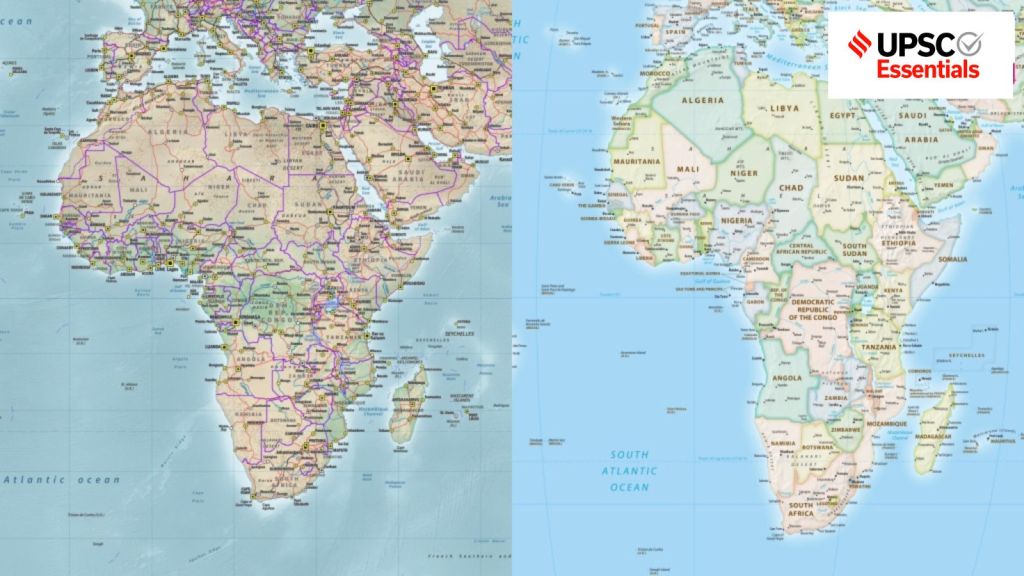 A composite image showing the Mercator map's projection of Africa (left), against the new Equal Earth projection. (File)
— Abhinav Rai
Map projection is the technique to draw all or part of the three-dimensional Earth on a flat surface. Given the shape and size of the Earth, such depictions involve a certain degree of compromise. Cartographers, therefore, have to make a trade-off between accurately representing direction, distance, area, and shape.

The Mercator projection, for instance, was designed to help navigators as it displays accurate compass bearings (preserves direction) and local shapes, but distorts larger areas and shapes when one moves poleward from the equator. Similarly, the Equal Earth projection, which is an equal area map, keeps size relatively accurate and compromises with the shape and direction. In a recent resolution, the UN endorsed the Equal Earth projection.
While making a map, cartographers have to choose which property of the earth’s surface should be represented accurately, for which purpose, and for whom, because maps not only represent physical boundaries but also have political and social meanings. In this context, let’s trace the historical evolution of map-making, including the mapping of the Indian sub-continent, and the recent development redefining the process of cartography.
How the World Got Mapped
The making of the world map
Anaximander, a Greek philosopher (610-546 BC), is considered to have prepared one of the earliest maps of the known world. This map was circular in shape and depicted three continents: Europe, Asia, and Libya, all of which were surrounded by the world ocean. Eratosthenes, a Greek mathematician, geographer, and astronomer (276-196 BC), calculated the Earth’s circumference (equator) with remarkable accuracy at 25,000 miles against the present accepted length of about 24,855 miles.
After him came Hipparchus, a Greek astronomer and mathematician (190-120 BC), who defined the equator as the great circle dividing the Earth into two equal halves. He divided the circle into 360 degrees and determined the grids of latitudes and longitudes along with projection systems to plot a three-dimensional spherical earth on the flat sheet of paper.
Roman geographer Claudius Ptolemy (90-168 AD), who believed geography is a science that deals with the art of map-making, wrote an eight-volume book titled, The Guide to Geography. The first volume was about map projection, six volumes catalogued all the known places according to their latitude and longitude, while the eighth volume contained maps of various parts of the world.
How the cartographic knowledge survived and evolved
However, with the disintegration of the Roman Empire soon after, the progress in scientific knowledge declined – the period that followed is referred to as the “Dark Ages”. Meanwhile, significant advancements in geographical knowledge were made outside Europe.
Arab and Muslim scholars translated Greek and Roman texts, including Ptolemy’s, into Arabic. Al-Idrisi (1099-1165 AD) corrected Ptolemy’s work using newly gathered information, notes R D Dikshit in his book, Geographical Thought – A Contextual History of Ideas (2004).
Dikshit also writes that the revival of cartography in Europe followed the Latin translation of Ptolemy’s work from a preserved copy in Byzantium (Istanbul) in 1410, and the capture of the Muslim base on the southern side of strait of Gibraltar by Portugal’s Prince Henry ‘The Navigator’ in 1415.
The first globe, showing a spherical earth, was created in 1490 by Martin Behaim. Patronage by Prince Henry led to the voyages of Christopher Columbus (1492) and Vasco da Gama (1498). This was the start of the age of exploration.
A revolutionary shift came in the exploration with the development of a projection method by Gerardus Mercator in 1569. However, it became easily reproducible only in 1599, when Edward Wright gave a trigonometric table for it. Despite showing distorted shapes of continents, it proved to be of great utility in sea navigation due to its advantages in showing true direction.
How India was mapped
Cartographic techniques that had initially been developed and used for navigation exploration acquired a new significance later when the East India Company (EIC) obtained the Diwani rights for revenue collection in Bengal, Bihar, and Orissa (now Odisha) in 1765 after winning the Battle of Plassey (1757). The company soon realised that effective tax collection required better knowledge of the terrain and society.
Therefore, the EIC appointed James Rennell as the first surveyor general of Bengal (1767-1777). He led the foundation of the present Survey of India. Rennell scientifically mapped parts of India in great detail and published the Atlas of Bengal (1779) and the Memoir of a Map of Hindoostan (1782).
After the Fourth Anglo-Mysore War (1799), the EIC’s control expanded to the territories of southern India and so did its ambitions. In 1802, William Lambton started the Great Trigonometrical Survey (GTS) with an aim to scientifically and accurately measure the whole Indian subcontinent. This whole exercise took several decades to complete.
Many Indians contributed to this exercise but received little credit for it. Among them were Pundit Nain Singh, who traveled to Lhasa (Tibet), and mathematician Radhanath Sikdar, whose calculation established the actual height of the World’s highest peak, which was later named Mount Everest. The mountain was named in honour of the surveyor George Everest by his successor, Andrew Scott Waugh.
Changing process and use of cartography in the digital age
The history of cartography shows how the purpose of maps has evolved from navigation and conquest to revenue collection, effective administration, and territorial management. Notably, the Equal Earth projection, endorsed by the UN, has faced objections from many countries, including Japan, India, and Ukraine.
Maps shape people’s spatial consciousness. For the longest time, maps meant physical objects, prepared mostly by national survey agencies that controlled their production, circulation, and updating. The arrival of modern techniques, such as GPS-based satellite navigation, Geographical Information System (GIS) integrated with the mapping apps in smartphones, has led to the creation of digital maps.
The next major development in mapping is the concept of ‘Digital Twin’. Esri defines it as ‘a virtual representation of reality, including physical objects, processes, and relationships’. Digital Twin acts as a real-time 3D replica of a physical place with the help of various sensors and data sources.
Beyond navigation, it can simulate various scenarios and predict outcomes, which can be helpful in decision-making. In the first such step towards port management, in February this year, India launched the Digital Twin initiative at the V. O. Chidambaranar Port in Tamil Nadu.
Complex realities of the digital map ecosystem
The Indian government notified the National Geospatial Policy in December 2022 to liberalise and democratise access to the country’s geospatial data. It is also aiming to establish a system for high-resolution (5–10 cm for urban/rural areas and 50–100 cm for forests/wastelands) topographical survey and mapping, and to generate a high-accuracy Digital Elevation Model (25 cm for plains, 1–3 m for hilly areas) by 2030.
Furthermore, there are plans to generate high-resolution bathymetric geospatial data for inland waters and deep-sea topography and to develop a National Digital Twin of major cities by 2035 to improve urban planning and management.
Moreover, some recent instances show the complex realities of the current digital map ecosystem. Last year, flights near Indian airports reported suspected GPS spoofing and GNSS interference. This year, India’s own navigation system, NavIC, became dysfunctional with only three working satellites broadcasting position signals against a minimum of four.
Separately, concerns related to digital sovereignty arose when US President Donald Trump issued an executive order to rename Lake Ontario as “Lake America”. The new name appeared on Google and Apple Maps for users in the US, while the same apps showed the older name for Canadian users.
Therefore, it may be argued that India needs to invest considerably in building high-resolution, indigenous mapping capacity and the infrastructure to back it.
Post read questions
1. Trace the evolution of cartographic techniques from Anaximander and Eratosthenes to Ptolemy and Mercator. How did advances in mathematical geography transform the representation of the Earth?
2. The Great Trigonometrical Survey was a landmark in the scientific mapping of India. Discuss its objectives, significance and the contribution of Indian surveyors to the enterprise.
3. Maps do not merely represent territory; they can also shape perceptions of territory. Explain in the context of contemporary geopolitics.
4. Digital maps have transformed geography from a static representation of space into a dynamic information system. Discuss the role of GPS, GIS, remote sensing and smartphones in this transformation.
5. What is a Digital Twin? How can it transform urban planning and infrastructure management in India?
(Abhinav Rai is a Doctoral candidate at the Department of Geography, Delhi School of Economics, University of Delhi.)
Share your thoughts and ideas on UPSC Special articles with ashiya.parveen@indianexpress.com.
Click Here to read the UPSC Essentials magazine for September 2026. Subscribe to our UPSC newsletter and stay updated with the news cues from the past week.
Stay updated with the latest UPSC articles by joining our Telegram channel – IndianExpress UPSC Hub, and follow us on Instagram and X.

 Share


