In his book Empire of the Raj (2004), historian Robert Blyth argues, “The Persian Gulf was the heart of the Indian sphere.” Indeed, the Indian subcontinent had been connected to the Gulf region through trade and migration for centuries, a reality that was built upon by the British when they established their empire in India.
Contrary to what modern maps of British India might make us believe, the territory of influence of the British Raj expanded far beyond the contours of India, Pakistan and Bangladesh. As Sam Dalrymple points out in his book, The Shattered Lands (2025), “As recently as 1928, a vast swathe of Asia–India, Pakistan, Bangladesh, Burma, Nepal, Bhutan, Yemen, Oman, the UAE, Qatar, Bahrain, Kuwait– were bound together under a single imperial banner, an entity known officially as the Indian empire, or more simply as the Raj.”

The British in India expanded their influence over the Gulf region for strategic, economic and geopolitical reasons. The expansion, though, was not done through direct colonisation, but rather by establishing indirect control through treaties, often referred to as the “system of protection”. They were legally a part of India, under the Interpretation Act of 1889.
In his book, Dalrymple notes that “they were run by the Indian Political Service, defended by the Indian Army, and subservient to the Viceroy of India.” Interestingly, the official list of princely states in India is known to have begun alphabetically with Abu Dhabi, while Lord Curzon is known to have argued that Oman was as much a native state of the Indian Empire as Lus Beyla or Kelat.
Surprisingly, though, the British were not keen on advertising the true extent of their empire. They played down the true size of the British Empire for diplomatic reasons and left out most of the protectorate states from their official maps.
Britain’s expansion into the ‘Middle East’
Britain’s original interest in Bahrain and Trucial Oman emerged out of strategic concerns for the protection of British shipping between Persia, Iraq, Muscat (Oman) and India. Historian of Middle Eastern Studies, James Onley, notes in his book, The Arabian Frontier of the British Raj’ (2007), that between 1797 and 1819, the British were extremely concerned by the Arab maritime raiders who had their base of operations at the ‘Pirate coast’ (as the Gulf coast of present day UAE was called).
Eventually, they dispatched a series of naval expeditions to the Gulf. Following the last such expedition, it became clear that the stability of the Gulf Shaikhdoms was critical for the security of British shipping. Thereafter, the British embarked upon a policy of increased interventions in the affairs of the Arab region, which they maintained till as recent as 1971. Accordingly, the British first established their residency at Bushire in Persia in 1763.
British concern in the region was further heightened when France sent a military expedition to Egypt in 1798 and later entered into a political alliance with the Shah of Persia in 1807. Suddenly, British India faced the threat of invasion on its western front. “Britain quickly adopted the policy of securing Persia and Muscat/Oman as buffer states against French influence,” writes Onley.
The opening of the Suez Canal in 1869 further increased the strategic importance of the region, cutting down the shipping time between Britain and India.
Finally, in the 1860s, Russia was expanding its sphere of influence in Central Asia to secure a warmwater port somewhere along the southern Persian coast. It added yet another layer of concern for the British, making the Gulf a key frontier in the ‘Great Game’ between Russia and Britain. “Throughout the 1800s this crucial geopolitical arena was then secured and transformed to become the bulwark of an informal imperial system erected around British India,” writes historian Guillemette Crouzet in her book, Inventing the Middle East: Britain and the Persian Gulf in the Age of Imperialism (2022).
This sphere of influence in the Gulf region was maintained through the collaboration among actors in London, on the Indian subcontinent and the Gulf region itself. Until 1858, operations in the Gulf territories were being conducted under the auspices of the Bombay presidency and thereafter by the government of India.
Cartographic expeditions were carried out to impose a geographical logic upon this region, whose political economy was reordered to favour imperial priorities. As pointed out by Crouzet in her book, officials and speculators sought new passages to India, often running through Mesopotamia, archaeologists unearthed artefacts of the region’s ancient empires, and ideologues envisaged the rebirth of ancient civilisations under British oversight.
By the end of the 19th century, notes Crouzet, a new appellation appeared to identify the Gulf region–the Middle East. This term, she writes, was hardly ever in use before the 1900s. Its emergence was a product of geopolitics rather than any cultural or religious identity. The British journalists and writers who first came up with the term marked the region through its connections to India. Valentine Chirol, one of the earliest British journalists to identify the ‘Middle East’ region for instance, wrote that the Middle East consisted of “those regions of Asia which extend to the borders of India or command the approaches to India, and which are consequently bound up with the problems of Indian political as well as military defence”.
Left out of maps
However, despite being a crucial part of the British Empire in India, the Gulf territories would often be left out of their official maps. This was done for diplomatic and pragmatic reasons. Dalrymple, in his book, explains that “the Arab states bordering the Ottoman Empire were usually left off the imperial maps altogether, to avoid aggravating Constantinople”. He writes that the absence of these states from British maps was much remarked upon at the time, and cites a lecturer to the Royal Asian Society, who is known to have joked, “As a jealous sheikh veils his favourite wife, so the British authorities shroud conditions in the Arab states in such thick mystery that ill-disposed propagandists might almost be excused for thinking that something dreadful is going on there.”
Onley explains in his book that the British were keen on maintaining the fiction that “some of its protected states bordering the territories of other empires did not form part of the Indian Empire and were only loosely connected to the British Empire.”
The Middle East after Indian independence
Up until as late as March 1947, the territories of the Persian Gulf were administered by the Indian Political Service. A decade ago, Aden in Yemen had undergone separation from British India. It was turned into a crown colony under the terms of the Government of India Act of 1935. During the Aden separation debates, it was decided that India would not be allowed to govern the Persian Gulf after Independence.
In his book, Dalrymple cites the Gulf resident William Hay as having said, “when the British decided to transfer power in India it would clearly have been inappropriate to hand over responsibility for dealing with the Gulf Arabs to Indians or Pakistanis.”
Accordingly, on April 1, 1947, the Persian Gulf Residency was finally separated from India. The Indian Political Service and Indian soldiers quickly and unceremoniously disappeared from the region. They were soon replaced by British officers. Then on, the Foreign Office in London assumed responsibility for the Gulf region.
Had this administrative transfer of power not taken place, it is quite likely that the states in the Gulf region would have ended up either in India or Pakistan.
In the ensuing years, history writing in India has hardly ever acknowledged the Indian Empire’s reach into present day Yemen and Dubai. Responding to why that was the case, Dalrymple explained in a previous interview with indianexpress.com that nationalists have written history presenting India “as this ancient thing called Bharat”. He explains that the Hindu nationalists from the Mahasabha said that the Arabian states should not be part of India because Arabia was a separate civilisation. “But the British were just conquering random territories based on economic sense, not on ‘Indianness’,” he said.

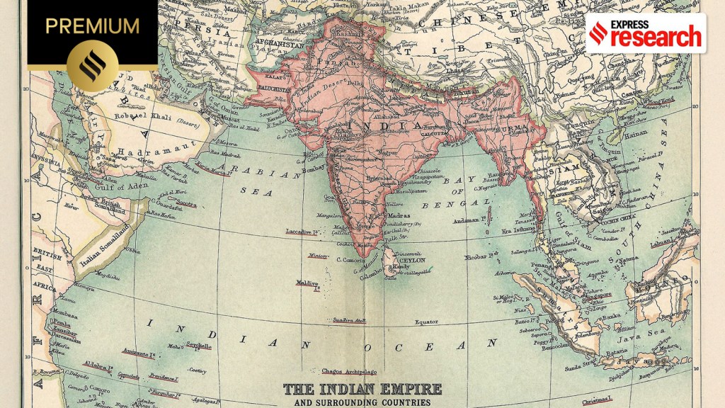 The British Raj and surrounding countries are shown in 1909. (Imperial Gazetteer of India, Volume XXVI)



 Share


