Journalism of Courage
Premium
This is an archive article published on April 2, 2017
Discovering the forgotten Dahisar river through a photographer’s lens
The 12 km-long river, which snakes through the northernmost part of Greater Mumbai, originates inside the Sanjay Gandhi National Park and empties into the Manori creek.

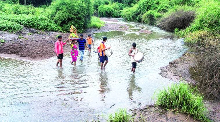 The 12 km-long river originates inside the Sanjay Gandhi National Park and empties into the Manori creek. Aslam Saiyad
With the Arabian Sea dominating Mumbai’s imagination, it is easy to forget that four rivers run through the city as well. That is until they force themselves on our attention, like the Mithi river did, when it flooded in July 2005. For the most part, however, the Mithi, along with the Oshiwara, Poisar and Dahisar, follow their ancient path towards the sea, often reduced to little more than nullahs. It was to draw attention to these rivers that city-based photographer Aslam Saiyad began a project called ‘Discovering the Forgotten Rivers of Bombay’ last year.
It is the Dahisar river that is the focus of the first part of Saiyad’s project. The 12 km-long river, which snakes through the northernmost part of Greater Mumbai, originates inside the Sanjay Gandhi National Park and empties into the Manori creek. “I grew up in Borivali and have been visiting the Sanjay Gandhi National Park for many years,” says Saiyad. “Inside the park, the river has a completely different character. It is beautiful and the water is clear. Children cool off inside it and along the banks of the river, tribal communities have built their lives.” So scenic was the river and its environs that it attracted not just picnickers, but also film crews. The upper reaches of the river, running through the park, teem with life, even harbouring the occasional marsh crocodile, many of which live in Vihar lake. During the monsoon, especially when the lake overflows into the river basin, these reptiles have been known to wander in as well. In fact, in August and September last year, crocodiles, including some hatchlings, had been sighted in the part of the river that runs through the tourism zone, leading the park authorities to issue a warning to visitors.
Immediately outside, however, the river changes completely, becoming little more than a sewer into which encroaching human settlements, dhobi ghats and tabelas dump their waste. “The biggest problem is the concretisation of the river basin,” says Kedar Ghorpade, former chief planner for the MMRDA. “It disrupts the natural flow of the river, which should be allowed to follow its natural contours. But reclamation of the basin and construction over it end up choking the river.” Ghorpade, who currently works as a development sustainability consultant, says that all is not lost and there is yet time to save the Dahisar. “It’s been done before with highly polluted rivers that flow through urban settlements, such as the Seine in France and the Rhine in Germany. What we need is not an engineering solution, but a landscape solution, which recognises the landscape through which the river flows, and which takes into account the river basin and the floodplains,” says Ghorpade.
In December last year, the dumping of cattle carcasses in the river had drawn wide public attention to the much-abused, disappearing river. But it should not require something like this to draw public attention in the first place, believes Saiyad. The photographer recently displayed his pictures of the Dahisar river along its banks, where passersby could stop and take a look. “One man who had stopped to look at the photographs came up to me and said he had been living in the area for 30 years but had no idea that a river existed there. He had always believed it to be a nullah. This is exactly why I think we need to keep drawing people’s attention to the existence of the river. Otherwise, we’ll forget they existed at all.”
Advertisement
Top Stories


Live Blog
PHOTOS


Top Stories


Advertisement
Must Read


Advertisement
Buzzing Now
TrendingBihar Election Results 2025: As NDA dominates early leads, social media turns counting day into meme fest

TrendingUS CEO reveals she fired 2 employees for cheating on their partners: ‘I can’t have this in my environment’


- 01
- 02
- 03
- 04
- 05
Advertisement