Nepal objected earlier this week to India and China announcing the reopening of border trade through the Lipulekh Pass, citing its claims over the region.
In an official statement, the Government of Nepal said it was “clear that the official map of Nepal, as incorporated in the Constitution of Nepal, includes Limpiyadhura, Lipulekh, and Kalapani — located east of the Mahakali River — as integral parts of Nepal.”
“It is well known that the Government of Nepal has been consistently urging the Government of India not to carry out any activities such as road construction/expansion or border trade in the said area. The Government of Nepal has also apprised our friendly neighbour, China, that this area is part of Nepali territory,” the statement said.
In response, Ministry of External Affairs spokesperson Randhir Jaiswal said, “Border trade between India and China through Lipulekh pass commenced in 1954 and has been going on for decades… such claims are neither justified nor based on… evidence.”
Nepal previously raised the claims in 2020, and then Prime Minister K P Sharma Oli passed a map in Parliament, showing the area as part of Nepal. The Indian Express then reported on the historical importance of this region and the territorial claims. What follows is a re-edited version of that story.
The 2020 incident
Former Army Chief General M M Naravane said on May 15, 2020, that Nepal’s protest against a newly built Indian road in Uttarakhand, up to Lipu Lekh pass on the China border, was at “someone else’s behest”. His statement was widely taken to mean that Nepal was acting as a proxy for China, at a time when tensions spiked sharply on the Line of Actual Control (LAC) between the Chinese People’s Liberation Army (PLA) and the Indian Army at Ladakh.
The road is on the route of the annual Kailash Mansarovar Yatra, which goes through Uttarakhand’s Pithoragarh district. Defence Minister Rajnath Singh, who inaugurated it on May 8, 2020, said the road, built by the Border Roads Organisation, was important for “strategic, religious and trade” reasons.
The 80 km road goes right up to the Lipu Lekh pass on the LAC, through which Kailash Mansarovar pilgrims exit India into China to reach the mountain and lake revered as the abode of Siva.
 A new route that goes through Nathu La to Lake Mansarovar in Tibet was opened in 2015 as a result of a memorandum signed in 2014 between India and China. (File)
An official statement said what used to be a difficult trek to the gateway, situated at 17,060 ft, would now be an easy road trip. Although some officials have said it should be possible to complete the entire distance from Delhi to Lipu Lekh in two days, the sharp rise in altitude from 6,000 ft at Ghatiabagarh, where the new road starts, may require a slower journey for better acclimatisation, at least for pilgrims.
The government underlined that through this improved route, yatris do not need the alternative routes for the pilgrimage, one through the Nathu La border in Sikkim and the other via Nepal, which entailed “20 per cent land journeys on Indian roads and 80 per cent land journeys in China … the ratio has been reversed. Now pilgrims to Mansarovar will traverse 84 per cent land journeys on Indian roads and only 16 per cent in China.”
The defence minister called it a “historic” achievement as he opened the road via video conferencing. The new road was also expected to provide better connectivity to Indian traders for the India-China border trade at the Lipu Lekh pass between June and September every summer.
Importance of the road
Building roads leading to the contested LAC with China has been a fraught exercise for the government. The India China Border Roads, as they are known, were conceptualised in the late 1990s by a consultative group called the China Studies Group, cleared at the highest level of the Cabinet Committee on Security, and given the go-ahead for construction in 1999.
But the deadlines were movable targets, and it was only in the wake of the 70-day Doklam stand-off with China in 2017, that India realised with shock that most of those roads had remained on the drawing board. In all those years, only 22 had been completed.
The Standing Committee on Defence, in its 2017-2018 report, noted that “the country, being surrounded by some difficult neighbours, with a view to keeping pace, construction of roads and development of adequate infrastructure along the borders is a vital necessity”.
Was Nepal’s objection sudden?
On the day the road was inaugurated in 2020, there was an outcry in Nepal. The next day, the Nepal Foreign Ministry issued a statement expressing disappointment over New Delhi’s “unilateral” act, which it said went against the spirit of the bilateral “understanding… at the level of Prime Ministers” to sort out border issues through negotiations.
It asked India to “refrain from carrying out any activity inside the territory of Nepal.” The Indian envoy in Kathmandu was summoned by the Nepal Foreign Ministry.
Some in India asked why Nepal was silent during the time that the road was being built. But Kathmandu pointed out that it has brought up its concerns on the border issue several times, including in November 2019, when Delhi put out its new political map of India to show the bifurcation of Jammu & Kashmir.
Nepal’s objection then was the inclusion of Kalapani in the map, in which it is shown as part of Uttarakhand. The area falls in the trijunction between India, China and Nepal.
The issue has come up now and again in the bilateral relationship since the 1960s. In the 1980s, the two sides set up the Joint Technical Level Boundary Working Group to delineate the boundary, which demarcated everything except Kalapani and the other problem area in Susta.
When it was discussed at the prime ministerial level in 2000, between Atal Bihari Vajpayee and B P Koirala during the latter’s visit to Delhi, both sides agreed to demarcate the outstanding areas by 2002. That has not happened.
The Nepal-India border was delineated by the Sugauli Treaty of 1816, under which it renounced all territory to the west of the river Kali, also known as the Mahakali or the Sarada river. The river effectively became the boundary. The terms were reiterated by a second treaty between Nepal and British India in 1923. The rival territorial claims centre on the source of the Kali.
Nepal’s case is that the river originates from a stream at Limpiyadhura, north-west of Lipu Lekh. Thus, Kalapani, Limpiyadhura, and Lipu Lekh fall to the east of the river and are part of Nepal’s Far West province in the district of Dharchula.
New Delhi’s position is that the Kali originates in springs well below the pass, and that while the Treaty does not demarcate the area north of these springs, administrative and revenue records going back to the nineteenth century show that Kalapani was on the Indian side, and counted as part of Pithoragarh district, now in Uttarakhand. Both sides have their own British-era maps as proof of their positions.
India-China-Nepal
Since the 1962 war with China, India has deployed the Indo Tibetan Border Police at Kalapani, which is advantageously located at a height of over 20,000 ft and serves as an observation post for that area.
Nepal calls it an encroachment by the Indian security forces. Nepal has also been unhappy about the China-India trading post at Lipu Lekh, the earliest to be established between the two countries. Shipkila in Himachal followed two years later, and Nathu La only in 2006.
Nepali youth protested in Kalapani, and there were protests in Nepal’s Parliament too when India and China agreed to increase border trade through Lipu Lekh during Prime Minister Narendra Modi’s visit to Beijing in 2016.
The Chinese newspaper Global Times, an accurate barometer of what the Chinese state is thinking on any international issue, then declared that Beijing should remain “neutral” and be mindful of the ”sensitivities in the India-Nepal relationship”.
A year later, during the Doklam crisis, a senior official in the Chinese Foreign Ministry raised temperatures by suggesting that India would not be able to do anything if the PLA decided to walk in “through Kalapani or into Kashmir, through PoK”, both trijunctions like Doklam.
Though China has said nothing about the road construction to Lipu Lekh, it has protested similar road-building activity at other places on the Indian side close to the LAC, including Ladakh.
In view of all this, Kalapani and the approach to Lipu Lekh have only grown in strategic importance for India, especially as relations between the two countries have remained uneven over the last few years, and China has upped its game for influence in India’s neighbourhood.
India’s tacit support for a blockade of the landlocked country during protests over the new Constitution in Nepal by the Madhesi community was an inflection point in the relationship. Despite the open border with India and the people-to-people contact through the hundreds of thousands of Nepali people who live and work in this country, the levels of distrust in Nepal about India have increased.
For its part, India perceived Nepal to be tilting towards China under the leadership of Prime Minister K P Oli and his Nepal Communist Party. Responding to Nepal’s protests, India said it was ready to discuss the matter at the foreign secretary-level talks between the two countries.
The talks were to be held earlier in 2020, but were put off due to the Covid-19 outbreak.

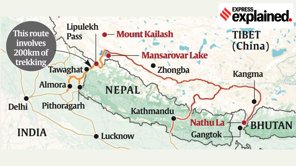 Ministry of External Affairs spokesperson Randhir Jaiswal said, “Border trade between India and China through Lipulekh pass commenced in 1954 and has been going on for decades." (Express graphic)

 A new route that goes through Nathu La to Lake Mansarovar in Tibet was opened in 2015 as a result of a memorandum signed in 2014 between India and China. (File)

 Share


