Prime Minister Narendra Modi is scheduled to flag off on Sunday a 34.5-kilometre elevated corridor in Assam’s Kaziranga, which, according to experts and forest officials, is expected to be a long-term solution to the increasing problem of animals being hit by heavy traffic in the national park.
The Rs 6,950-crore corridor will be part of a major existing highway connecting the national park and Eastern Assam to the state capital, Guwahati, and its aim is to enable safer passage for animals to cross. Currently, the highway disrupts their natural movement during floods.
The Kaziranga National Park, which has the world’s largest population of the one-horned rhinoceros and is home to 37 species of mammals and nearly 500 species of birds, is located on the Brahmaputra floodplains in Central Assam’s Nagaon and Eastern Assam’s Golaghat districts. National Highway 715 (earlier NH-37) — a crucial roadway connecting Tezpur, a major town on the North Bank of the Brahmaputra, to towns in Eastern Assam — forms the southern boundary of the national park, and across it lie the hills of Karbi Anglong.
In October this year, the Union government’s Cabinet Committee on Economic Affairs approved the widening of a two-lane 86.675-km stretch of this highway to four lanes. A major part of this stretch passes along the boundary of the park or through it, and the approved project involves the construction of a 34.5-km elevated corridor, leaving an area underneath for the cross-movement of animals from the national park to the Karbi Anglong Hills.
According to the government, this will involve upgrading 30.22 km of existing roads and constructing 21 km of greenfield bypasses around the towns of Jakhalabandha and Bokakhat, and aims to “decongest the existing corridor, improve safety, and enhance the direct connectivity” between Guwahati, Kaziranga National Park, and the industrial town of Numaligarh.
Increased human traffic poses a threat
The national highway and the traffic passing through it pose one of the major threats to wildlife in the national park.
According to Dr Rathin Barman, Director of Wildlife Trust of India, the wider landscape of the region — from the low-lying Brahmaputra floodplains, wetlands and grasslands to the highlands of Karbi Anglong — is the natural habitat of many animals.
“The Kaziranga boundary is defined by humans, not animals. And when floods occur and submerge large parts of the national park, which is a natural phenomenon, animals move south to the highlands and later come back down when the floods recede. But now, because of development, we have the highway and human habitations in the area, which have disrupted this natural passage,” he said.
Attempts by animals to cross this busy highway, which has an average daily traffic of 13,800 passenger cars this financial year, can be deadly.
A Gauhati University research team, comprising Zoology Department faculty members Prasanta Kumar Saikia and Malabika Kakati Saikia, as well as research scholar Somoyita Sur, had in 2022 studied the roadkill mortality on this stretch of NH-715 between October 2016 and September 2017. It recorded 6,036 individual animals killed in collisions with vehicles during this period, including an Indian leopard, of which 63.6% occurred during the flooding period of April to September.
The study said, “The major factor contributing to these roadkills is the high speed of the vehicles. Thus, the reduction of speed should be managed, along with proper mitigation designs for the safe movement and existence of all animals… [W]e need not put a stop to development but rather incorporate proper and eco-friendly designs and innovations in tandem with it, in order to reduce vehicular collisions in intrusions within any protected area.”
According to Kaziranga Divisional Forest Officer Arun Vignesh, the problem was only growing with time.
“The traffic on the road passing through the Karbi Anglong-Kaziranga landscape is increasing day by day. It is the continuous movement of vehicles that is blocking this passage. So, we are in a time in which we need to find a passage for these animals, which can be managed if we ensure the movement of heavier traffic through the elevated road,” he said.
Safeguarding the animals of the park
The DFO said there have been interventions to try to control this problem with the existing infrastructure. “We have animal sensor systems in six stretches identified as major crossing areas, which alert us if the animals move close to the highway. When this happens, the traffic is immediately regulated on the stretch. But this is a limited intervention,” he said.
There have been concerns voiced by some activists that the construction activity required to implement a project of this scale in such a sensitive zone will itself be a major source of disturbance to the wildlife in the area.
However, Dr Barman from the WTI said he believed the overpass could be “a permanent solution” to a long-standing problem. “With measures focusing on minimising the disturbance during the construction, this can be a permanent solution to a problem that I have seen in the 30 years that I have been in this field. Since traffic has been increasing, this problem had only been growing. This is a crucial roadway, and since we cannot deny development, there has to be a way to take development and conservation hand-in-hand,” he said.

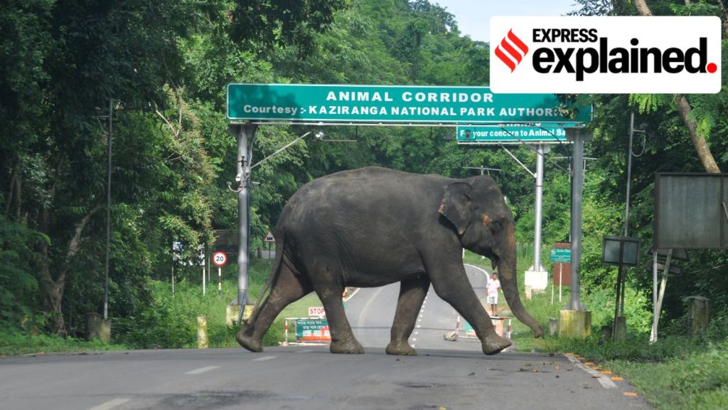 The national highway and the traffic passing through it pose one of the major threats to wildlife in the national park. (Express File Photo)



 Share


