At the UN general assembly session, 164 countries (including India) voted to adopt the 2018 Equal Earth design — with the US voting against the resolution, and six countries abstaining.
While UN resolutions are not binding, the vote may result in an update of classroom curriculums and technology.
But the important aspect to keep in mind here is that no flat map of the globe can ever be truly accurate.
There are many different methods of portraying a three-dimensional sphere on a two-dimensional surface, and each comes with its own drawbacks or distortions. The one you pick depends on the purpose you need it for.
In the case of the Mercator projection, these distortions are most evident in the shrinking of the vast African continent — making it look similar in size to the much smaller Greenland.
The 2018 Equal Earth design, which was developed by an international team of cartographers, also comes with its own limitations. But its supporters say it will help reverse perceptions of Africa and “decolonise” global curriculums, The Guardian reported.
So how did the Mercator map come to be the most commonly used depiction of the word? Why has it been criticised for a “colonial” lens? And how does the new map improve, and not improve, upon it? We explain.
The origins of the Mercator projection: A map for sailors
Gerardus Mercator (1512-94), a mathematician and engraver, created the map in 1569 to help sailors navigate their way around the globe. The map’s first version was a set of 18 sheets, which formed a wall-size mosaic 48 inches high by 80 inches wide (Rhumb Lines and Map Wars: A Social History of the Mercator Projection, Mark Monmonier, 2004).
 Mercator’s 1569 world map. Wikimedia Commons
Mercator projected the Earth’s surface as if unwrapped from a cylinder around the globe. It had a grid pattern with longitudes (or meridians) and latitudes (or parallels) at 90-degree angles. The lines of longitude were evenly spaced, but the distance between the lines of latitude increased away from the equator, which was placed at the centre of the map. This allowed a straight line between any two points on the map to be the correct direction for sailors to follow using their compasses.
The Mercator map revolutionised travel and became the standard world map for atlases and wall maps by the 19th century. “Wall-map publishers readily embraced the Mercator map’s rectangular format… [and] schoolbooks and classroom atlases also promoted the Mercator worldview,” wrote Monmonier.
Distorting the real size
In recent years, however, the Mercator map has been criticised for distorting the sizes of the world’s continents.
When Mercator displayed the near-spherical Earth as a rectangle on a flat surface with the equator at the centre, it left large, confusing gaps near the poles. So, he stretched out the northern and southern ends of the globe to fill them — and thus produced a usable map.
However, as a result of this manoeuvre, areas closer to the poles — such as Canada, Russia, the United States, and Europe — appear bigger than they are. And Africa — which straddles the equator — looks smaller than it is.
Even tropical countries like India appear smaller than they actually are. And Greenland, which is about the size of the Democratic Republic of the Congo, seems to be of the same size as the whole of Africa.
Mercator’s projection helped Western cartographers to easily mark towns, cities, and roads in their part of the world.
“In some situations centering a map near the viewer’s location is good design. But if you’re a humanist well versed in European imperialism’s harsh imprint on the Third World, the traditional Greenwich-anchored world map becomes a clear example of Western cultural hegemony, and all the more so when a Mercator projection inflates the size of western Europe,” wrote Monmonier.
Why this matters
An episode of the American political drama TV series The West Wing, showed a group of socially minded cartographers in the White House explaining the bias implicit in the Mercator map.
Indeed, critics have argued that the diminution of Africa on the map contributed to its exploitation by the colonial West.
“The standard projection was a political tool that contributed to the scramble for Africa, also known as the partition of Africa when Western European powers colonised the continent. Just as making Africa look small and conquerable then, the Mercator projection makes the continent look small and irrelevant now,” Rabah Arezki, former economist at the World Bank, wrote in Le Monde.
In response to this, advocacy groups Africa No Filter and Speak Up Africa led the Correct the Map campaign, which was endorsed by the African Union. Selma Malika Haddadi, deputy chairperson of the African Union, had told Reuters last year that the Mercator map’s rejection would help reclaim “Africa’s rightful place on the global stage”.
The other popular types of projections
While the Mercator projection has, correctly, attracted much criticism, it is worth remembering that areas and shapes can be depicted accurately only on a globe. Every method of projecting a globe on a flat surface comes with tradeoffs, depending on what you are using it for.
“Is it going to be used to measure distances or directions? Angles? Areas? Show distributions of thematic data, you know, population?” Fritz Kessler, a map projection expert, told NPR this year.
A map projection will distort at least one of these four aspects: Area (how large a landmass is relative to others), shape (the true outline and appearance of a country), distance (the actual space between two points) and direction (the correct compass bearing from one location to another). In the case of the Mercator projection, it was the shapes that were prominently distorted.
There are many types of map projections (cylindrical, conic, or azimuthal) and many projections based on these types or their combinations. Here’s a look at some of the most famous projections that were widely used:
The Gall-Peters projection. Wikimedia Commons
The attempts to find a better projection began centuries ago. As long back as 1855, a Scottish clergyman named James Gall presented a new projection at a science convention. In 1973, a very similar map was reintroduced by Arno Peters, a German historian and gained widespread attention. While the Gall-Peters projection preserves area accurately, it severely distorts the shape of countries, making them appear stretched or squashed. In 2017, schools in Boston introduced this projection.
The Robinson projection. Wikimedia Commons
In 1963, geographer Arthur H. Robinson devised the Robinson projection which tried to better balance the sizes and shapes of land masses and sought to solve the “Greenland problem”. The meridians curve gently, but stretch the poles into long lines instead of leaving them as points, as can be seen in the image. Hence the distortion close to the poles is severe, though this moderates once you move away from them.
The Winkel Tripel projection. Wikimedia Commons
In 1921, a German cartographer named Oswald Winkel devised the Winkel Tripel projection, seeking to reduce distortion across area, distance and direction. In 1998, it replaced the Robinson projection in world maps made by the National Geographic Society. Schools and textbooks followed, as did the World Bank. The Winkel Tripel reduces overall distortion, but does not preserve area, shape, distance or direction perfectly. The distortion is more evident near the poles.
The Equal Earth projection. Wikimedia Commons
The Equal Earth projection was developed in 2018. It shows continents mostly in their correct relative sizes, but it avoids some of the severe shape distortions seen in Gall-Peters. The UN resolution said: “Equal Earth cartographic projection offers a more accurate representation of the sizes of continental landmasses and to this end is a relevant option for improving the accuracy of the cartographic representation of the world.” This, too, is not free of criticism: shapes and distances get distorted towards the poles.
A World Bank spokesperson told Reuters that they already use the Winkel-Tripel or Equal Earth for static maps and are phasing out Mercator on web maps.
Google Maps switched from Mercator on desktop to a 3D globe view in 2018, though users can still switch back to the Mercator if they prefer. On the mobile app, however, the Mercator projection remains the default, Reuters reported.
This is an updated version of an explainer that originally went up on August 20, 2025.

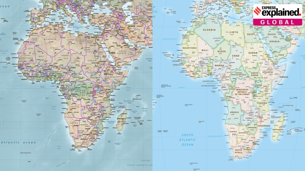 A composite image showing the Mercator map's projection of Africa (left), against the new Equal Earth projection.

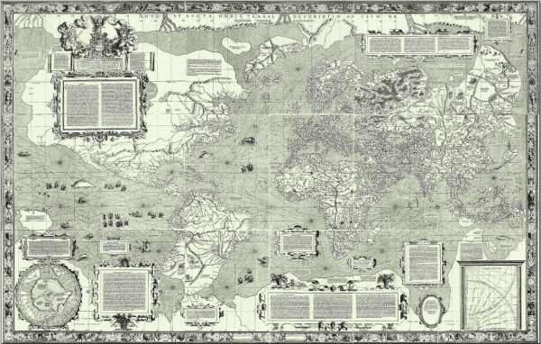 Mercator’s 1569 world map. Wikimedia Commons
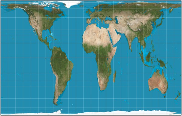 The Gall-Peters projection. Wikimedia Commons
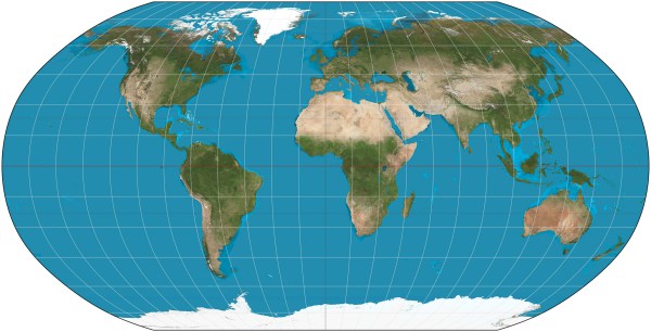 The Robinson projection. Wikimedia Commons
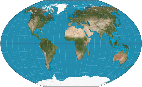 The Winkel Tripel projection. Wikimedia Commons
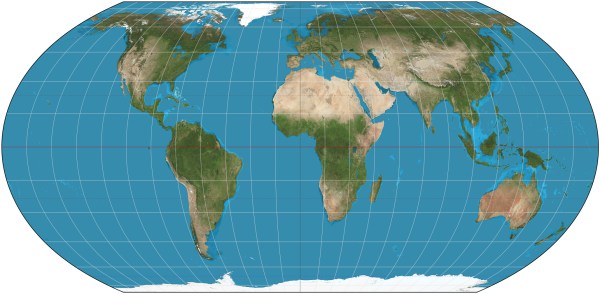 The Equal Earth projection. Wikimedia Commons

 Share


