


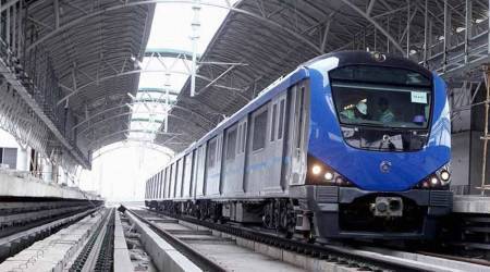


The Chennai Metro is an urban Mass Rapid Transit System (MRTS) serving Tamil Nadu’s capital city Chennai. Started in 2015, the Chennai Metro is the 4th longest metro network in India. As of March 2022, the Chennai Metro has two operational metro lines and three lines under-construction. The Chennai Metro is built and operated by the Chennai Metro Rail Corporation (CMRL). The Chennai Metro system has a mix of elevated and underground metro stations.
The aim of the project, according to the CMRL website, is to provide the people of Chennai with a “fast, reliable, convenient, efficient, modern and economical mode of public transport, which is properly integrated with other forms of public and private transport including buses, sub-urban trains and MRTS.”
The Chennai Metro Rail Corporation is a joint venture between the Government of Tamil Nadu and the Union Government of India.
The Phase I of the Chennai Metro was commissioned stage-wise. The first segment of section between Alandur to Koyambedu was commissioned on 29th June, 2015. The first Underground line between Thirumangalam Metro Station to Nehru Park Metro Station was inaugurated on 14th May, 2017. The Underground stretches – Nehru Park Metro Station to Chennai Central Metro Station and Saidapet Metro Station to AG-DMS metro Station were opened a year later on 25th May, 2018. On 10th February, 2019, the Underground stretch from AG-DMS to Washermenpet of blue line was opened, completing 45 km network under the Phase I of the Metro Rail Project.
Chennai Metro Route Map
Chennai Metro has two operational metro lines, which are the blue line and green line. Chennai Metro also has three under construction lines.
Chennai Metro Operational Lines (Phase 1, Phase 1 Extension)
Line-1 – Blue Line: Chennai Airport Metro Station – Wimco Nagar Metro Station (32.15 km, 25 stations)
Line-2 – Green Line: Chennai Central Metro Station – St. Thomas Mount Metro Station (22 km, 17 stations)
According to the CMRL website, the Phase – I of Chennai Metro Rail project covers a length of 45.046 km network and consists of two Corridors i.e. Corridor-I – From Washermenpet Metro Station to Airport Metro Station (23.085 Km), Corridor -2 – From Chennai Central Metro Station to St. Thomas Mount Metro Station (21.961 km). About 55 per cent of the Corridors in Phase –I is Underground and the remaining are elevated. Out of 32 nos of Stations, 13 nos are elevated stations and the remaining 19 numbers are underground stations. Inter Corridor interchange Stations are available in Alandur (elevated) and Chennai Central (underground) respectively.
Story continues below this ad
Phase I Extension covers a length of 9.05 km from Washermenpet Metro Station to Wimco Nagar Metro Station. It consists of 9 Metro Stations and an elevated depot. Out of nine metro stations, seven numbers are elevated stations and the remaining two are underground stations and the same was commissioned on February 14, 2021 from Washermenpet Metro Station to Wimco Nagar Metro Station except Thiruvottriyur Theradi Metro Station and Wimco Nagar Depot Metro Station. The remaining two Metro stations were commissioned on March 13, 2022.
See Chennai Metro Map Routes
Chennai Metro Map by Express Web on Scribd
Chennai Metro Phase 1 Metro Map by Express Web on Scribd
Chennai Metro Corridor-I – From Washermenpet to Airport (23.085 Km)
| Station Name | Elevation |
|
Wimco Nagar Depot Metro Station |
Elevated |
|
Wimco Nagar Metro Station |
Elevated |
|
Tiruvottriyur Metro Station |
Elevated |
|
Tiruvottriyur Theradi Metro Station |
Elevated |
|
Kaladipet Metro Station |
Elevated |
|
Tollgate Metro Station |
Elevated |
|
New Washermanpet Metro station |
Elevated |
|
Tondiarpet Metro Station |
Underground |
|
Sir Theagaraya College Metro Station |
Underground |
|
Washermanpet Metro Station |
Underground |
|
Mannadi Metro Station |
Underground |
|
High Court Metro Station |
Underground |
|
Puratchi Thalaivar Dr. M.G. Ramachandran Central Metro Station |
Underground |
|
Government Estate Metro Station |
Underground |
|
LIC Metro Station |
Underground |
|
Thousand Lights Metro Station |
Underground |
|
AG – DMS Metro Station |
Underground |
|
Teynampet Metro Station |
Underground |
|
Nandanam Metro Station |
Underground |
|
Saidapet Metro Station |
Underground |
|
Little Mount Metro Station |
Elevated |
|
Guindy Metro Station |
Elevated |
|
Arignar Anna Alandur Metro Station |
Elevated |
|
Nanganallur Road Metro Station |
Elevated |
|
Meenambakkam Metro Station |
Elevated |
|
Chennai International Airport Metro Station |
Elevated |
Story continues below this ad
Corridor -2 – From Chennai Central to St. Thomas Mount (21.961 km)
| Station Names | Elevation |
|
Chennai Central Metro Station |
Underground |
|
Egmore Station Metro Station |
Underground |
|
Nehru Park Metro Station |
Underground |
|
Kilpauk Medical College Metro Station |
Underground |
|
Pachaiyappa’s College Metro Station |
Underground |
|
Shenoy Nagar Metro Station |
Underground |
|
Anna Nagar East Metro Station |
Underground |
|
Anna Nagar Tower Metro Station |
Underground |
|
Thirumangalam Metro Station |
Underground |
|
Koyambedu Metro Station |
Elevated |
|
CMBT Metro Station |
Elevated |
|
Arumbakkam Metro Station |
Elevated |
|
Vadapalani Metro Station |
Elevated |
|
Ashok Nagar Metro Station |
Elevated |
|
Ekkattuthangal Metro Station |
Elevated |
|
Alandur Metro Station |
Elevated |
|
St. Thomas Mount Metro Station |
Elevated |
Chennai Metro Approved Lines (Phase 2)
Line-3 (Purple Line): Madhavaram Metro Station – SIPCOT 2 Metro Station (45.813 km, 49 stations)
Line-4 (Orange Line): Light House Metro Station – Poonamallee Bus Depot Metro Station (26.1 km, 30 stations)
Line-5 (Red Line): Madhavaram Metro Station – Sholinganallur Metro Station (47 km, 48 stations)
Chennai Metro PHASE II
Phase II expansion has been planned for a length of 118.9 Km network with 128 Metro stations. It consists of three corridors – Corridor -3 – From Madhavaram Metro Station to SIPCOT Metro Station (45.8 Km), Corridor -4 – From Lighthouse Metro Station to Poonamalle Bypass Metro Station (26.1 Km), Corridor-5- From Madhavaram Metro Station to Sholinganallur Metro Station (47 Km). The estimated cost of the project is ₹63246 cr. This proposal is under the process and approval of Government of India. The project is proposed to be completed by the end of 2026.
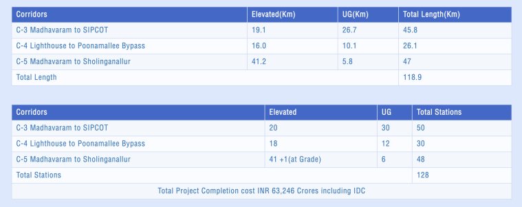 Source: Chennai Metro Rail Limited (https://chennaimetrorail.org/)
Chennai Metro Fares
The minimum charge at the Chennai Metro is Rs 10, and the maximum has been capped at Rs 50. The fares depend upon the distance travelled by the passenger.
Story continues below this ad
Chennai Metro Timings
The Chennai Metro is functional on all seven days of the week from Mondays to Sundays between 5 am to 11 pm. The frequency of one train remains 4-5 minutes during peak hours and 15 minutes during lean hours.