Cyclonic storm Asna over northeast Arabian Sea is likely to continue on its trajectory, moving west-northwestwards away from the Indian coast during next 24 hours, the India Meteorological Department (IMD) said Saturday.
Under the effect of the weather system, heavy to very heavy rains are expected at isolated places in the districts of Saurashtra-Kutch namely Jamnagar, Porbandar, Dwarka and Kutch.
According to satellite observations as of 11.30 am on Friday, the storm had started moving away from the Indian coast, missing Gujarat.
Impact so far
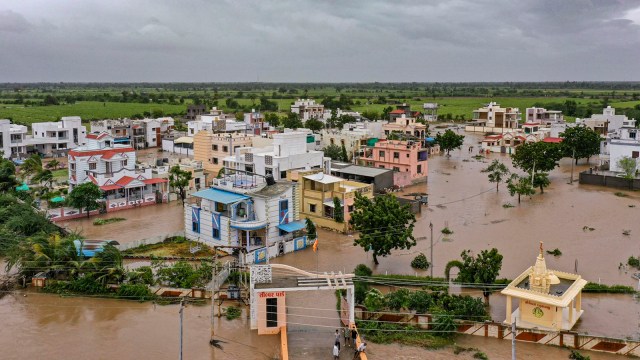
The weather system has already caused extreme weather in the state, and as a precautionary measure, the local administration had shifted nearly 3,500 persons to safer locations and asked people living in huts and mud houses to take shelter in other buildings, said Kutch district collector Amit Arora, reported PTI.
On Friday, Gujarat’s Rajkot, Devbhoomi Dwarka, Jamnagar, Vadodara, Kutch and Saurashtra regions received very heavy to extremely heavy rainfall.
Some of the affected areas were Mandvi (300 mm), Mundra (220 mm), Okha (171 mm), Abdasa (160 mm), Naliya (156 mm), Dwarka (80 mm), Bhuj (57 mm) and Kandla (41 mm).
Over the past week, the rainfall received by Gujarat jumped from 638.3 mm to 927 mm due to the deep depression. The rainfall in the Saurashtra-Kutch region went from 477.4 mm to 799.
In its latest forecast, the IMD said heavy rainfall (64-115 mm in 24 hours) will continue over Gujarat till Saturday. After a brief lull, heavy rainfall is expected over the Kutch-Saurashtra region on September 2 and 3.
Story continues below this ad
Deep depression turns into rare cyclone ‘Asna’
Yesterday, a deep depression off the Gujarat coast had intensified into the cyclone — only the first of its kind to form over the Arabian Sea since 1964. The cyclone acquired the name Asna, given by Pakistan.
IMD’s data on depressions and cyclones reveals that depressions or their intensification originating in the Arabian Sea was recorded in 1961, 1964 and 2022. But none of these developed into a cyclone. Whereas, depressions intensifying into cyclones while on landmass were reported during 1926, 1944 and 1976.
Cyclones intensifying in the Bay of Bengal or the Arabian Sea are more common during the pre-monsoon March-May and the post-monsoon October-December periods. The strongest of these storms have developed during May and November. In light of strong monsoon currents and other unfavourable ocean factors, these systems rarely intensify into cyclones during the June-September season — making Cyclone Asna a rare development.